|
search place name
|
||
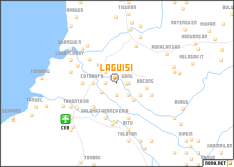
Laguisi (Cotabato, Philippines)Laguisi is a town in the Cotabato region of Philippines. An overview map of the region around Laguisi is displayed below.
regional and 3d topo map of Laguisi, Philippines ::
Laguisi airports ::
The nearest airport is CEB - Cebu Cotabato, located 9.9 km south west of Laguisi.
Other airports nearby include LGP - Legazpi Pagadian (113.4 km north west), CGY - Ladag Cagayan De Oro (137.4 km north), Nearby towns ::
Nuling (1.5km east) //
Matampay (1.8km west) //
Bulibud (1.8km west) //
Salimbao (1.8km west) //
Busao (1.9km south) //
Pañgangcalan (1.8km east) //
Mabar (1.8km east) //
Patawali (1.8km east) //
Bacaon-Matampay (1.8km east) //
Dameda (1.8km east) //
Landap (1.8km east) //
Kurmatan (1.8km east) //
Pidtimbasan (1.8km east) //
Banatin (1.8km east) //
Nalinan (1.8km east) //
Maidapa (1.8km east) //
Bulalo (1.8km east) //
Ladiya (1.8km east) //
Daguruñgan (1.8km east) //
Dagubek (1.8km east) //
Dalumangcob (1.8km east) //
Pinaring (1.8km east) //
Dinomolog (1.8km east) //
Bayabao (1.8km east) //
Gang (1.8km east) //
Pusao (1.8km east) //
Pigkelegan (1.8km east) //
Ruboken (1.8km east) //
Rasañgan (1.8km east) //
[all distances 'as the bird flies' and approximate]  Places with similar names to Laguisi, Philippines ::
Disclaimer :: Information on this page comes without warranty of any kind |
||
|
Where is Laguisi? Elevation and coordinates ::
Latitude (lat): 7°13'0"N Longitude (lon): 124°17'0"E
Elevation (approx.): 5m (map arrows pan, magnifying glasses zoom) |
||
|
Visiting Laguisi? Hotel/Accommodation ::
Book a hotel in Laguisi Travel Guide ::
Buy a travel guide for Philippines rental cars ::
car rental offers GPS waypoint ::
download a GPX waypoint (PoI) of Laguisi for your GPS receiver
|
||