|
search place name
|
||
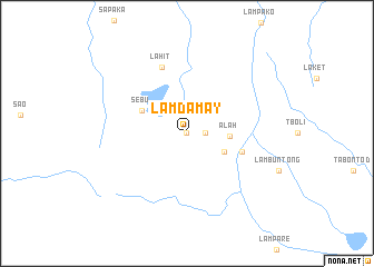
Lamdamay (South Cotabato, Philippines)Lamdamay is a town in the South Cotabato region of Philippines. An overview map of the region around Lamdamay is displayed below.
regional and 3d topo map of Lamdamay, Philippines ::
Lamdamay airports ::
The nearest airport is CEB - Cebu Cotabato, located 121.4 km north west of Lamdamay.
Other airports nearby include LGP - Legazpi Pagadian (228.5 km north west), Nearby towns ::
Libas (0.0km north) //
Manese (0.0km north) //
Lampaday (0.0km north) //
Lamyan (0.0km north) //
Laonay (0.0km north) //
Selten (1.8km east) //
Talfao (1.8km east) //
Tafagang (4.1km south east) //
Alah (4.3km east) //
Sebu (5.0km north west) //
Landamay (5.8km east) //
Lahit (7.1km north) //
[all distances 'as the bird flies' and approximate]  Places with similar names to Lamdamay, Philippines ::
// Lomba da Maia (PT)
// Lomba do Moio (PT)
// La Madama (CU)
// Lambatama (ID)
// Lemahtamba (ID)
// Lembodouma (GA)
// Lemboudouma (GA)
// Lemboudouma (GA)
// Liembo Douma (GA)
// Lem Dam (SN)
Disclaimer :: Information on this page comes without warranty of any kind |
||
|
Where is Lamdamay? Elevation and coordinates ::
Latitude (lat): 6°12'0"N Longitude (lon): 124°44'0"E
Elevation (approx.): 814m (map arrows pan, magnifying glasses zoom) |
||
|
Visiting Lamdamay? Hotel/Accommodation ::
Book a hotel in Lamdamay Travel Guide ::
Buy a travel guide for Philippines rental cars ::
car rental offers GPS waypoint ::
download a GPX waypoint (PoI) of Lamdamay for your GPS receiver
|
||