|
search place name
|
||
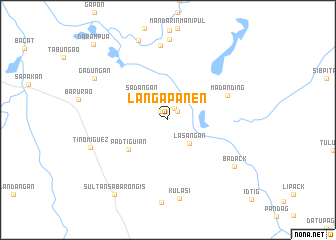
Langapanen (Sultan Kudarat, Philippines)Langapanen is a town in the Sultan Kudarat region of Philippines. An overview map of the region around Langapanen is displayed below.
regional and 3d topo map of Langapanen, Philippines ::
Langapanen airports ::
The nearest airport is CEB - Cebu Cotabato, located 62.1 km north west of Langapanen.
Other airports nearby include CGY - Ladag Cagayan De Oro (170.6 km north), LGP - Legazpi Pagadian (172.0 km north west), Nearby towns ::
Sambuan (1.2km north west) //
Zamboangan (1.4km north east) //
Sambuluan (1.4km north east) //
Agkayamet (1.5km north east) //
Lasañgan (3.5km south east) //
Sadañgan (4.0km north west) //
Padtiguian (5.5km south west) //
Madanding (7.1km north east) //
Panosolon (8.3km north) //
Liguasan (8.3km north) //
Pidtiguian (8.3km north) //
Kulasi (8.8km south) //
Badack (9.0km south east) //
Tinomiguez (9.1km west) //
Gadungan (9.4km north west) //
Kalbugan (9.5km north) //
Sultan sa Barongis (10.3km south west) //
Darampua (11.8km north west) //
[all distances 'as the bird flies' and approximate]  Places with similar names to Langapanen, Philippines :: Disclaimer :: Information on this page comes without warranty of any kind |
||
|
Where is Langapanen? Elevation and coordinates ::
Latitude (lat): 6°52'31"N Longitude (lon): 124°41'26"E
Elevation (approx.): 17m (map arrows pan, magnifying glasses zoom) |
||
|
Visiting Langapanen? Hotel/Accommodation ::
Book a hotel in Langapanen Travel Guide ::
Buy a travel guide for Philippines rental cars ::
car rental offers GPS waypoint ::
download a GPX waypoint (PoI) of Langapanen for your GPS receiver
|
||