|
search place name
|
||
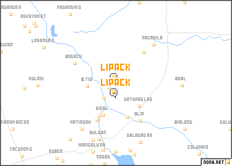
Lipack (Maguindanao, Philippines)Lipack is a town in the Maguindanao region of Philippines. An overview map of the region around Lipack is displayed below.
regional and 3d topo map of Lipack, Philippines ::
Lipack airports ::
The nearest airport is CEB - Cebu Cotabato, located 78.3 km north west of Lipack.
Other airports nearby include CGY - Ladag Cagayan De Oro (180.1 km north), LGP - Legazpi Pagadian (188.2 km north west), Nearby towns ::
Damakling (1.4km south west) //
Lipack (2.3km south) //
Pandag (3.1km south west) //
Idtig (4.7km west) //
Datu Paglas (5.2km south east) //
Digal (5.6km south) //
Botel (5.9km south) //
Baguiang (5.9km south west) //
Tulunan (6.7km north east) //
Malañget (6.7km south west) //
Alip (7.2km south east) //
Badack (7.3km north west) //
Malasila (8.6km north east) //
Matingaw (9.2km south west) //
[all distances 'as the bird flies' and approximate]  Places with similar names to Lipack, Philippines ::
Disclaimer :: Information on this page comes without warranty of any kind |
||
|
Where is Lipack? Elevation and coordinates ::
Latitude (lat): 6°48'0"N Longitude (lon): 124°49'0"E
Elevation (approx.): 13m (map arrows pan, magnifying glasses zoom) |
||
|
Visiting Lipack? Hotel/Accommodation ::
Book a hotel in Lipack Travel Guide ::
Buy a travel guide for Philippines rental cars ::
car rental offers GPS waypoint ::
download a GPX waypoint (PoI) of Lipack for your GPS receiver
|
||