|
search place name
|
||
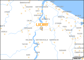
Lucban (Kalinga-Apayao, Philippines)Lucban is a town in the Kalinga-Apayao region of Philippines. An overview map of the region around Lucban is displayed below.
regional and 3d topo map of Lucban, Philippines ::
Lucban airports ::
The nearest airport is BAG - Baguio, located 233.3 km south of Lucban.
Nearby towns ::
Colonia Number Two (0.0km north) //
Colonia Parcela Number One (2.6km north west) //
Aguanta (2.6km north east) //
Gubu (2.8km north east) //
Guiddam (3.4km east) //
Pagappo (3.5km east) //
Batubatu (4.1km north east) //
Camarugan (5.3km east) //
Santa Marcela (5.6km south) //
Simayung (5.6km north) //
Alam (5.8km south) //
Tumoc (5.6km west) //
Bungan (5.8km north) //
San Isidro (5.6km west) //
Calog (6.0km north west) //
Banguian (6.7km north) //
Lasila (7.4km north) //
Canayun (7.5km north) //
Pilig (7.6km south) //
Sirit (7.6km north) //
Zitanga (7.3km east) //
Malunog (7.7km south west) //
Nararagan (7.7km south east) //
Luna (8.5km west) //
Tuccac (10.2km south west) //
Sipa (10.2km south west) //
Pimpila (11.1km north west) //
[all distances 'as the bird flies' and approximate] 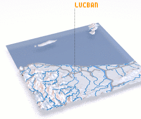 Places with similar names to Lucban, Philippines ::
Disclaimer :: Information on this page comes without warranty of any kind |
||
|
Where is Lucban? Elevation and coordinates ::
Latitude (lat): 18°20'0"N Longitude (lon): 121°26'0"E
Elevation (approx.): 10m (map arrows pan, magnifying glasses zoom) |
||
|
Visiting Lucban? Hotel/Accommodation ::
Book a hotel in Lucban Travel Guide ::
Buy a travel guide for Philippines rental cars ::
car rental offers GPS waypoint ::
download a GPX waypoint (PoI) of Lucban for your GPS receiver
|
||