|
search place name
|
||
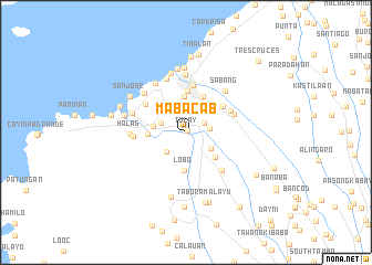
Mabacab (Cavite, Philippines)Mabacab is a town in the Cavite region of Philippines. An overview map of the region around Mabacab is displayed below.
regional and 3d topo map of Mabacab, Philippines ::
Mabacab airports ::
The nearest airport is MNL - Manila Ninoy Aquino Intl, located 38.0 km north east of Mabacab.
Nearby towns ::
Tulay (0.2km north east) //
Molino (2.0km north east) //
Malainen Luma (2.3km east) //
Bukal (2.7km west) //
Capantayan (2.8km south west) //
Capotulan (2.8km north west) //
Caputatan (2.9km north west) //
Balayungan (2.9km south east) //
Mojon (3.0km north west) //
Maragondon (3.2km west) //
Malini (3.6km north) //
Lobo (3.8km south) //
General Mariano Riego de Dios (3.7km west) //
Buli (3.7km west) //
Pantihan No. 1 (3.8km south east) //
Pasong Calobcob (4.0km north east) //
Malainen Bago (4.2km north) //
Halang (4.5km north east) //
San Roque (4.8km north) //
Muzon (4.8km north west) //
Pasong Tiron (4.9km north east) //
Palangue (5.0km east) //
Pantihan No. 2 (5.2km south east) //
Pinagsanghan (5.2km west) //
Halag (5.5km west) //
San Juan (5.6km north west) //
Ternate (5.6km west) //
Sabang (5.7km north east) //
Bancaan (5.8km north) //
[all distances 'as the bird flies' and approximate] 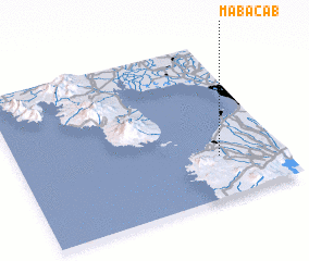 Places with similar names to Mabacab, Philippines ::
// Mobokabi (CD)
Disclaimer :: Information on this page comes without warranty of any kind |
||
|
Where is Mabacab? Elevation and coordinates ::
Latitude (lat): 14°16'4"N Longitude (lon): 120°46'4"E
Elevation (approx.): 41m (map arrows pan, magnifying glasses zoom) |
||
|
Visiting Mabacab? Hotel/Accommodation ::
Book a hotel in Mabacab Travel Guide ::
Buy a travel guide for Philippines rental cars ::
car rental offers GPS waypoint ::
download a GPX waypoint (PoI) of Mabacab for your GPS receiver
|
||