|
search place name
|
||
Macusi (Cagayan, Philippines)Macusi is a town in the Cagayan region of Philippines. An overview map of the region around Macusi is displayed below.
regional and 3d topo map of Macusi, Philippines ::

Macusi airports ::
The nearest airport is BAG - Baguio, located 187.6 km south west of Macusi.
Nearby towns ::
Dodan (1.0km north) //
Peñablanca (1.4km south west) //
Cabbo (1.9km south) //
Caggay (1.9km north) //
Concong (1.8km west) //
Bugatay (2.7km south east) //
Nannarian (3.6km north) //
Larion (3.7km west) //
Cabasan (3.9km south east) //
Alimannao (4.0km north west) //
Libag (5.6km south west) //
Capatan (5.7km south west) //
Callao (6.3km north) //
Gosi (6.4km south west) //
Parabba (6.5km north east) //
Tagga (6.7km south) //
Linao (6.5km north west) //
Carig (6.6km north west) //
Caggay (6.5km west) //
Malibabag (7.0km north) //
Abaca (7.0km south east) //
Comablam (7.3km south) //
Ruyu (7.3km west) //
Aggugadan (7.8km north) //
San Isidro (8.0km south west) //
Tuguegarao City (8.1km west) //
Atulayan (8.1km west) //
Alibago (8.8km south west) //
Lagum (9.1km north east) //
[all distances 'as the bird flies' and approximate] 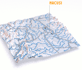 Places with similar names to Macusi, Philippines ::
Disclaimer :: Information on this page comes without warranty of any kind |
||
|
Where is Macusi? Elevation and coordinates ::
Latitude (lat): 17°38'0"N Longitude (lon): 121°48'0"E
Elevation (approx.): 31m (map arrows pan, magnifying glasses zoom) |
||
|
Visiting Macusi? Hotel/Accommodation ::
Book a hotel in Macusi Travel Guide ::
Buy a travel guide for Philippines rental cars ::
car rental offers GPS waypoint ::
download a GPX waypoint (PoI) of Macusi for your GPS receiver
|
||