|
search place name
|
||
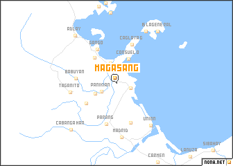
Magasang (Surigao del Sur, Philippines)Magasang is a town in the Surigao del Sur region of Philippines. An overview map of the region around Magasang is displayed below.
regional and 3d topo map of Magasang, Philippines ::
Magasang airports ::
The nearest airport is CGY - Ladag Cagayan De Oro, located 180.0 km south west of Magasang.
Other airports nearby include TAC - Tacloban Daniel Z Romualdez (232.2 km north west), NOP - Masbate Mactan Cebu Intl (241.8 km north west), Nearby towns ::
Cantilan (2.4km east) //
Panikian (2.8km south west) //
Carrascal (3.3km north) //
Gibioc (3.7km south west) //
Consuelo (4.3km north east) //
Manag-as (5.3km north west) //
Parang (5.8km south west) //
Gango (6.1km north west) //
Babuyan (6.5km west) //
Caglayag (6.7km north) //
Parang (6.8km south) //
Bogsokan (6.8km south) //
Taganito (7.4km west) //
Madrid (8.8km south) //
Union (8.8km south east) //
Buenavista (9.6km north east) //
Adlay (10.0km north west) //
Cabangahan (10.4km south west) //
Isla General (10.6km north east) //
[all distances 'as the bird flies' and approximate]  Places with similar names to Magasang, Philippines ::
Disclaimer :: Information on this page comes without warranty of any kind |
||
|
Where is Magasang? Elevation and coordinates ::
Latitude (lat): 9°20'29"N Longitude (lon): 125°57'26"E
Elevation (approx.): 12m (map arrows pan, magnifying glasses zoom) |
||
|
Visiting Magasang? Hotel/Accommodation ::
Book a hotel in Magasang Travel Guide ::
Buy a travel guide for Philippines rental cars ::
car rental offers GPS waypoint ::
download a GPX waypoint (PoI) of Magasang for your GPS receiver
|
||