|
search place name
|
||
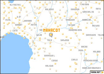
Mahacot (Batangas, Philippines)Mahacot is a town in the Batangas region of Philippines. An overview map of the region around Mahacot is displayed below.
regional and 3d topo map of Mahacot, Philippines ::
Mahacot airports ::
The nearest airport is MNL - Manila Ninoy Aquino Intl, located 82.4 km north of Mahacot.
Nearby towns ::
Catandala (1.2km east) //
Paharang (2.0km south) //
Tolo (2.4km south) //
Dumantay (2.5km west) //
San Pedro (2.9km north west) //
Sampaga (3.4km south west) //
Catandala (3.4km north east) //
Conde Labac (3.5km south) //
Mabalor (3.9km east) //
Bago (4.1km north west) //
Sabang (4.1km north west) //
Balanga (4.3km north east) //
Dilao (4.3km west) //
Bilogo (4.5km south east) //
Gulod (4.5km west) //
Dumuclay (4.8km south west) //
Siranglupa (5.0km south west) //
Panghayaan (5.1km east) //
Dayapan (5.2km north east) //
Luksuhin (5.2km north) //
Coliat (5.2km north) //
Sandalan (5.2km north) //
Palindan (5.2km north) //
Quilo (5.2km north) //
San Jose (5.2km south east) //
Tinga Ibaba (5.4km north west) //
Talumpoc (5.5km south east) //
Ibaan (5.6km north) //
Sorosoro (5.6km north west) //
[all distances 'as the bird flies' and approximate]  Places with similar names to Mahacot, Philippines ::
Disclaimer :: Information on this page comes without warranty of any kind |
||
|
Where is Mahacot? Elevation and coordinates ::
Latitude (lat): 13°46'14"N Longitude (lon): 121°7'23"E
Elevation (approx.): 108m (map arrows pan, magnifying glasses zoom) |
||
|
Visiting Mahacot? Hotel/Accommodation ::
Book a hotel in Mahacot Travel Guide ::
Buy a travel guide for Philippines rental cars ::
car rental offers GPS waypoint ::
download a GPX waypoint (PoI) of Mahacot for your GPS receiver
|
||