|
search place name
|
||
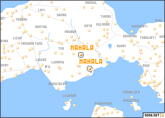
Mahala (Sulu, Philippines)Mahala is a town in the Sulu region of Philippines. An overview map of the region around Mahala is displayed below.
regional and 3d topo map of Mahala, Philippines ::
Mahala airports ::
The nearest airport is ZAM - Zamboanga Intl, located 150.3 km north east of Mahala.
Nearby towns ::
Marsada (1.8km south west) //
Bual Nangka (1.8km south) //
Niug Sangahan (2.3km north west) //
Sapa Bunuan (3.1km north east) //
Kabatuhan Tiis (3.1km north west) //
Bangon Banga (3.3km south) //
Tuyang (3.5km south east) //
Bagsak (3.5km north) //
Talipaw (3.6km north) //
Mahala (3.6km south east) //
Mabahay (3.9km south) //
Lung Kiaban (4.0km east) //
Kabungkul (4.1km east) //
Lambana (4.4km north east) //
Talipaw (4.5km south west) //
Lianagan (4.7km north) //
Tubod (4.7km north west) //
Kuhawa (4.8km north east) //
Tiis (4.9km west) //
Liban (4.9km north) //
Lubok-Lubok (5.4km east) //
Ipil (5.5km south west) //
Mauboh (5.6km north west) //
Kambangtuli (5.6km north west) //
Binuang (5.7km north east) //
Luboc (5.7km east) //
Lumapid (5.8km west) //
Samak (5.9km north west) //
Binuang (6.4km west) //
[all distances 'as the bird flies' and approximate]  Places with similar names to Mahala, Philippines ::
Disclaimer :: Information on this page comes without warranty of any kind |
||
|
Where is Mahala? Elevation and coordinates ::
Latitude (lat): 5°56'40"N Longitude (lon): 121°6'58"E
Elevation (approx.): 148m (map arrows pan, magnifying glasses zoom) |
||
|
Visiting Mahala? Hotel/Accommodation ::
Book a hotel in Mahala Travel Guide ::
Buy a travel guide for Philippines rental cars ::
car rental offers GPS waypoint ::
download a GPX waypoint (PoI) of Mahala for your GPS receiver
|
||