|
search place name
|
||
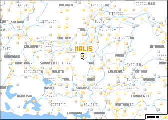
Malis (Bulacan, Philippines)Malis is a town in the Bulacan region of Philippines. An overview map of the region around Malis is displayed below.
regional and 3d topo map of Malis, Philippines ::
Malis airports ::
The nearest airport is MNL - Manila Ninoy Aquino Intl, located 42.2 km south of Malis.
Other airports nearby include BAG - Baguio (169.3 km north), Nearby towns ::
Pintog (2.3km east) //
Tabang (2.3km west) //
Santo Cristo (2.6km north west) //
Santa Ines (2.6km north west) //
Lalañgan (2.6km north west) //
Bañga (2.6km north west) //
Lumang Bayan (2.6km north west) //
Lagundi (2.6km north west) //
Nabuag (2.6km north west) //
Agnaya (2.6km north west) //
Bulihan (2.6km north east) //
Tiaong (2.6km south east) //
Tabe (2.6km south east) //
Santa Rita (2.9km south west) //
Parulan (3.4km north) //
Plaridel (3.6km north west) //
Canboac (3.7km north) //
Ligas (3.6km west) //
Bungahan (3.6km west) //
Guiguinto (3.7km south) //
Tuktukan (3.7km south) //
Santol (3.7km south east) //
Tabang (3.8km south west) //
Kutkot (4.1km north west) //
Longos (4.1km north west) //
Sipat (4.0km north west) //
Tikay (4.0km south west) //
Santol (4.0km south east) //
Dalig (4.0km south east) //
[all distances 'as the bird flies' and approximate] 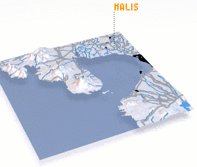 Places with similar names to Malis, Philippines ::
Disclaimer :: Information on this page comes without warranty of any kind |
||
|
Where is Malis? Elevation and coordinates ::
Latitude (lat): 14°52'0"N Longitude (lon): 120°53'0"E
Elevation (approx.): 5m (map arrows pan, magnifying glasses zoom) |
||
|
Visiting Malis? Hotel/Accommodation ::
Book a hotel in Malis Travel Guide ::
Buy a travel guide for Philippines rental cars ::
car rental offers GPS waypoint ::
download a GPX waypoint (PoI) of Malis for your GPS receiver
|
||