|
search place name
|
||
Manancas (Sorsogon, Philippines)Manancas is a town in the Sorsogon region of Philippines. An overview map of the region around Manancas is displayed below.
regional and 3d topo map of Manancas, Philippines ::

Manancas airports ::
The nearest airport is TAC - Tacloban Daniel Z Romualdez, located 189.0 km south east of Manancas.
Other airports nearby include KLO - Kalibo (213.0 km south west), ILO - Iloilo (271.0 km south west), Nearby towns ::
Calayogan (1.8km east) //
Salvacion (2.4km east) //
La Esperanza (3.6km east) //
San Eugenio (3.6km east) //
San Isidro (3.6km east) //
Pañge (3.9km south west) //
Bariis (4.1km south east) //
Busaingan (4.1km south east) //
Liang (4.1km north west) //
Santa Magdalena (4.3km east) //
Pawa (4.7km south) //
San Sebastian (5.2km south east) //
Catmon (5.2km south east) //
Calibag (5.5km south) //
Sisigon (5.4km west) //
Pagni (5.4km west) //
Manjumlad (5.8km south) //
Culasi (5.8km south) //
Lamboon (5.8km north) //
Mansibog (5.8km south) //
Irosin (6.5km north west) //
Candomaay (6.6km south east) //
Tabontabon (6.6km north west) //
San Julian (6.6km north west) //
San Juan (6.6km north west) //
Gulangulang (6.6km north west) //
Macawayan (6.6km north west) //
San Benon (6.6km north west) //
San Agustin (6.6km north west) //
[all distances 'as the bird flies' and approximate] 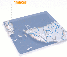
Disclaimer :: Information on this page comes without warranty of any kind |
||
|
Where is Manancas? Elevation and coordinates ::
Latitude (lat): 12°39'0"N Longitude (lon): 124°4'0"E
Elevation (approx.): 153m (map arrows pan, magnifying glasses zoom) |
||
|
Visiting Manancas? Hotel/Accommodation ::
Book a hotel in Manancas Travel Guide ::
Buy a travel guide for Philippines rental cars ::
car rental offers GPS waypoint ::
download a GPX waypoint (PoI) of Manancas for your GPS receiver
|
||