|
search place name
|
||
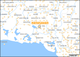
Manasahan (Bulacan, Philippines)Manasahan is a town in the Bulacan region of Philippines. An overview map of the region around Manasahan is displayed below.
regional and 3d topo map of Manasahan, Philippines ::
Manasahan airports ::
The nearest airport is MNL - Manila Ninoy Aquino Intl, located 39.5 km south east of Manasahan.
Other airports nearby include BAG - Baguio (174.0 km north), Nearby towns ::
Motimbo (0.4km east) //
Atlag (0.9km west) //
Mambag (1.7km east) //
Balete (1.9km north) //
Santa Isabel (1.9km north) //
Santo Cristo (1.9km north) //
Bagna (1.8km west) //
Taal (1.8km east) //
Look Segundo (1.8km east) //
Masile (2.6km south west) //
Bangkal (2.6km south east) //
Pitpitan (3.2km east) //
Malolos (3.7km north west) //
Caniugan (3.7km north) //
Sumapa (3.7km north) //
Dakila (3.7km north) //
Balagtas (3.6km east) //
Mabolo (4.1km north west) //
Barihan (4.1km north west) //
Kaingin (4.1km north west) //
Barasoain (4.1km north west) //
Anilao (4.1km north west) //
Catmon (4.1km north west) //
Kanalate (4.1km north west) //
Balayong (4.1km north west) //
Lugam (4.1km north west) //
Guinhawa (4.1km north west) //
Namayan (4.1km north west) //
Liyang (4.1km north west) //
[all distances 'as the bird flies' and approximate] 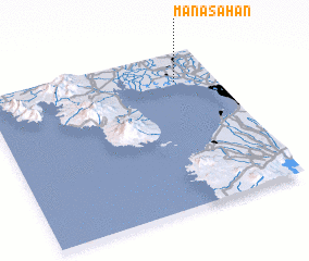 Places with similar names to Manasahan, Philippines :: Disclaimer :: Information on this page comes without warranty of any kind |
||
|
Where is Manasahan? Elevation and coordinates ::
Latitude (lat): 14°49'0"N Longitude (lon): 120°50'0"E
Elevation (approx.): 3m (map arrows pan, magnifying glasses zoom) |
||
|
Visiting Manasahan? Hotel/Accommodation ::
Book a hotel in Manasahan Travel Guide ::
Buy a travel guide for Philippines rental cars ::
car rental offers GPS waypoint ::
download a GPX waypoint (PoI) of Manasahan for your GPS receiver
|
||