|
search place name
|
||
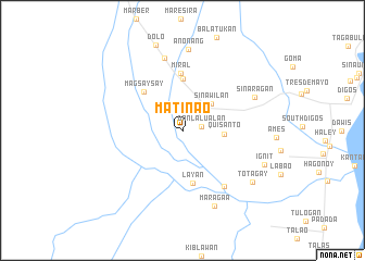
Matinao (Davao del Sur, Philippines)Matinao is a town in the Davao del Sur region of Philippines. An overview map of the region around Matinao is displayed below.
regional and 3d topo map of Matinao, Philippines ::
Matinao airports ::
The nearest airport is CEB - Cebu Cotabato, located 121.4 km north west of Matinao.
Other airports nearby include CGY - Ladag Cagayan De Oro (198.0 km north), LGP - Legazpi Pagadian (229.1 km north west), Nearby towns ::
Danlalualan (1.9km east) //
Sinawilan (4.0km north east) //
Quisanto (4.3km east) //
Bansalan (5.3km north) //
Layan (5.6km south) //
Magsaysay (5.6km north west) //
Miral (5.8km north) //
Matanao (7.2km south east) //
Matingao (7.6km north) //
Sinaragan (8.1km north east) //
Anonang (8.4km north) //
Maraga-a (8.4km south east) //
Tolagan (8.9km south east) //
Totagay (8.9km south east) //
Ignit (9.1km south east) //
Dolo (9.2km north) //
[all distances 'as the bird flies' and approximate] 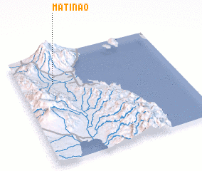 Places with similar names to Matinao, Philippines ::
Disclaimer :: Information on this page comes without warranty of any kind |
||
|
Where is Matinao? Elevation and coordinates ::
Latitude (lat): 6°43'51"N Longitude (lon): 125°13'7"E
Elevation (approx.): 70m (map arrows pan, magnifying glasses zoom) |
||
|
Visiting Matinao? Hotel/Accommodation ::
Book a hotel in Matinao Travel Guide ::
Buy a travel guide for Philippines rental cars ::
car rental offers GPS waypoint ::
download a GPX waypoint (PoI) of Matinao for your GPS receiver
|
||