|
search place name
|
||
Matubang (Capiz, Philippines)Matubang is a town in the Capiz region of Philippines. An overview map of the region around Matubang is displayed below.
regional and 3d topo map of Matubang, Philippines ::

Matubang airports ::
The nearest airport is KLO - Kalibo, located 62.4 km north west of Matubang.
Other airports nearby include ILO - Iloilo (66.2 km south), BCD - Bacolod (71.5 km south), SJI - San Jose Antique (106.9 km south west), NOP - Masbate Mactan Cebu Intl (169.8 km south east), Nearby towns ::
Lawa-an (1.6km north) //
Astorga (3.3km south east) //
Badbaranan (4.1km south) //
Carataya (5.7km north east) //
Agdajon (6.6km north west) //
Gibato (6.9km south east) //
Calapawan (7.0km north west) //
Guinotos (7.0km west) //
Janguslub (7.6km west) //
Malonoy (7.7km west) //
Bonod (7.8km north west) //
Agsalay (7.8km west) //
Tagobong (8.0km south) //
Maindang (8.1km north west) //
Tamulalud (8.2km south west) //
Lamunan (8.3km south) //
Salgan (8.4km north) //
San Antonio (8.5km north east) //
Bungsuan (8.6km south west) //
Sinabsaban (8.7km north east) //
Dumarao (8.7km west) //
Lidom (9.1km west) //
Villaflores (9.4km north east) //
Mapulang Bato (9.5km north west) //
Malagab-i (9.7km north west) //
[all distances 'as the bird flies' and approximate] 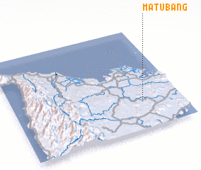 Places with similar names to Matubang, Philippines ::
// Matabang (PH)
// Matabang (PH)
// Matabang (PH)
// Matabang (PH)
// Madibeng (ZA)
// Madibong (ZA)
// Meadowbank (ZA)
// Modubeng (ZA)
// Mudubung (ZA)
// Modia-Bangou (BJ)
Disclaimer :: Information on this page comes without warranty of any kind |
||
|
Where is Matubang? Elevation and coordinates ::
Latitude (lat): 11°16'9"N Longitude (lon): 122°46'8"E
Elevation (approx.): 44m (map arrows pan, magnifying glasses zoom) |
||
|
Visiting Matubang? Hotel/Accommodation ::
Book a hotel in Matubang Travel Guide ::
Buy a travel guide for Philippines rental cars ::
car rental offers GPS waypoint ::
download a GPX waypoint (PoI) of Matubang for your GPS receiver
|
||