|
search place name
|
||
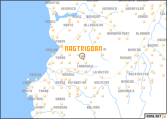
Nagtrigoan (Ilocos Norte, Philippines)Nagtrigoan is a town in the Ilocos Norte region of Philippines. An overview map of the region around Nagtrigoan is displayed below.
regional and 3d topo map of Nagtrigoan, Philippines ::
Nagtrigoan airports ::
The nearest airport is BAG - Baguio, located 177.1 km south of Nagtrigoan.
Nearby towns ::
Natrigoan (0.9km south east) //
Puzol (1.5km south west) //
Tartarabang (1.5km south west) //
Puritac (1.5km south west) //
Capangdanan (1.5km south west) //
Daldalayap (1.6km north west) //
Cabaroan (2.7km south) //
Upon (2.9km south west) //
Salnap (2.9km south west) //
Pinili (2.9km south west) //
Cullabeng (3.1km west) //
Comcomloong (3.2km west) //
Dalayap (3.2km west) //
Gulpeng (4.0km south west) //
Balaybay (4.0km south west) //
Badio-Laud (4.1km south west) //
Cubol (4.2km north west) //
Quiom (4.2km east) //
Bungro (4.5km south) //
Colo (4.6km north east) //
Pias Norte (4.8km north west) //
Burayoc (4.9km north) //
Tapao (4.8km west) //
Cabu-usan (4.9km west) //
Anggapang Sur (4.9km west) //
Magnuang (5.3km north) //
Parang (5.4km south west) //
Barbar (5.4km south west) //
Napo (5.4km south west) //
[all distances 'as the bird flies' and approximate]  Places with similar names to Nagtrigoan, Philippines :: Disclaimer :: Information on this page comes without warranty of any kind |
||
|
Where is Nagtrigoan? Elevation and coordinates ::
Latitude (lat): 17°58'25"N Longitude (lon): 120°32'42"E
Elevation (approx.): 73m (map arrows pan, magnifying glasses zoom) |
||
|
Visiting Nagtrigoan? Hotel/Accommodation ::
Book a hotel in Nagtrigoan Travel Guide ::
Buy a travel guide for Philippines rental cars ::
car rental offers GPS waypoint ::
download a GPX waypoint (PoI) of Nagtrigoan for your GPS receiver
|
||