|
search place name
|
||
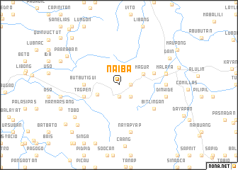
Naiba (Ilocos Sur, Philippines)Naiba is a town in the Ilocos Sur region of Philippines. An overview map of the region around Naiba is displayed below.
regional and 3d topo map of Naiba, Philippines ::
Naiba airports ::
The nearest airport is BAG - Baguio, located 65.5 km south of Naiba.
Nearby towns ::
Mapacac (1.8km east) //
Tacbo (1.9km south) //
Nalidaoan (1.9km south) //
Napayeo (2.6km south east) //
Matocbo (2.6km south east) //
Man-atong (3.6km south west) //
Magur (4.0km north east) //
Butbutigui (5.3km west) //
Mabec (5.6km east) //
Tagpen (5.6km west) //
Butac (5.6km west) //
Bitlingan (6.5km south east) //
Amgayang (7.1km east) //
Baliling (7.3km east) //
Nayapyap (7.6km south) //
Dinwide (7.3km east) //
Malaya (7.4km east) //
Tobo (8.4km south west) //
Dain (8.7km north east) //
Tibo (8.9km south west) //
Paaraban (9.0km north west) //
Mamarsang (10.1km south west) //
San Ramon (10.3km north west) //
Duquis (10.3km north west) //
Guinosod (10.3km north west) //
Laglagan (10.3km south west) //
Sigay (11.5km north west) //
[all distances 'as the bird flies' and approximate]  Places with similar names to Naiba, Philippines ::
Disclaimer :: Information on this page comes without warranty of any kind |
||
|
Where is Naiba? Elevation and coordinates ::
Latitude (lat): 16°58'0"N Longitude (lon): 120°39'0"E
Elevation (approx.): 1013m (map arrows pan, magnifying glasses zoom) |
||
|
Visiting Naiba? Hotel/Accommodation ::
Book a hotel in Naiba Travel Guide ::
Buy a travel guide for Philippines rental cars ::
car rental offers GPS waypoint ::
download a GPX waypoint (PoI) of Naiba for your GPS receiver
|
||