|
search place name
|
||
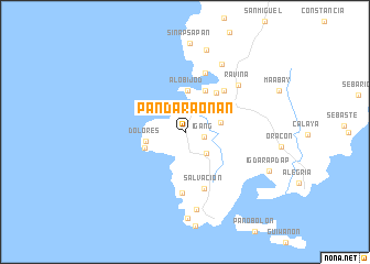
Pandaraonan (Iloilo, Philippines)Pandaraonan is a town in the Iloilo region of Philippines. An overview map of the region around Pandaraonan is displayed below.
regional and 3d topo map of Pandaraonan, Philippines ::
Pandaraonan airports ::
The nearest airport is ILO - Iloilo, located 24.3 km north of Pandaraonan.
Other airports nearby include BCD - Bacolod (48.2 km east), SJI - San Jose Antique (70.2 km north west), KLO - Kalibo (131.8 km north), DGT - Dumaguete (154.8 km south east), Nearby towns ::
Igang (2.0km east) //
Lucmayan (3.0km south east) //
Nueva Valencia (3.2km north east) //
Concordia (3.7km east) //
Dolores (4.0km west) //
Alobijod (4.2km north) //
Tando (4.3km west) //
Puyo (4.7km north east) //
Santa Ana (5.0km north east) //
Cabilao (5.7km north east) //
Salvacion (6.1km south) //
Binbanan (6.2km south) //
Murutan (6.4km north) //
Ravina (7.1km north east) //
Buluañgan (7.8km north east) //
La Paz (8.0km south) //
Lawi (8.6km north) //
Alman Sur (8.8km south) //
Igdarapdap (9.3km south east) //
[all distances 'as the bird flies' and approximate] 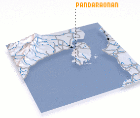 Places with similar names to Pandaraonan, Philippines :: Disclaimer :: Information on this page comes without warranty of any kind |
||
|
Where is Pandaraonan? Elevation and coordinates ::
Latitude (lat): 10°29'45"N Longitude (lon): 122°30'52"E
Elevation (approx.): 23m (map arrows pan, magnifying glasses zoom) |
||
|
Visiting Pandaraonan? Hotel/Accommodation ::
Book a hotel in Pandaraonan Travel Guide ::
Buy a travel guide for Philippines rental cars ::
car rental offers GPS waypoint ::
download a GPX waypoint (PoI) of Pandaraonan for your GPS receiver
|
||