|
search place name
|
||
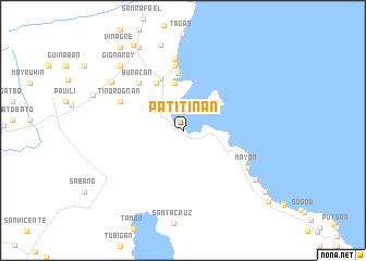
Patitinan (Camarines Sur, Philippines)Patitinan is a town in the Camarines Sur region of Philippines. An overview map of the region around Patitinan is displayed below.
regional and 3d topo map of Patitinan, Philippines ::
Patitinan airports ::
The nearest airport is KLO - Kalibo, located 243.2 km south west of Patitinan.
Nearby towns ::
Mabca (4.9km north) //
Taragui (4.9km north) //
Minadonghol (5.5km north west) //
Atulayan (5.5km north west) //
Kilomaon (5.5km north west) //
Sibaguan (5.5km north west) //
Aniog (5.5km north west) //
Sagnay (5.7km north west) //
Nato (5.9km north) //
Buracan (6.5km north west) //
Turague (6.7km north) //
Tinorogñan (6.9km north west) //
Huyonhuyon (7.4km north) //
Mayon (7.5km south east) //
Salvacion (8.7km north west) //
Misibis (8.8km south east) //
San Miguel (9.0km north) //
Caraycayon (9.1km north west) //
Gigñaroy (9.1km north west) //
Coyaoyao (9.6km north west) //
Tigaon (10.1km north west) //
Maynonong (10.3km south east) //
Vinagre (10.5km north west) //
May-anao (10.5km north west) //
San Francisco (10.5km north west) //
Gubat (10.5km north west) //
Talojogñon (10.5km north west) //
Ocini (10.5km north west) //
Joroan (11.2km south east) //
[all distances 'as the bird flies' and approximate] 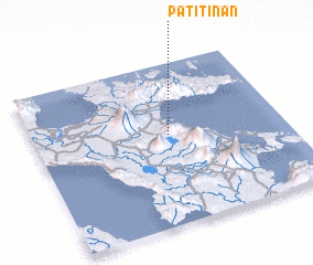 Places with similar names to Patitinan, Philippines :: Disclaimer :: Information on this page comes without warranty of any kind |
||
|
Where is Patitinan? Elevation and coordinates ::
Latitude (lat): 13°33'24"N Longitude (lon): 123°32'27"E
Elevation (approx.): 4m (map arrows pan, magnifying glasses zoom) |
||
|
Visiting Patitinan? Hotel/Accommodation ::
Book a hotel in Patitinan Travel Guide ::
Buy a travel guide for Philippines rental cars ::
car rental offers GPS waypoint ::
download a GPX waypoint (PoI) of Patitinan for your GPS receiver
|
||