|
search place name
|
||
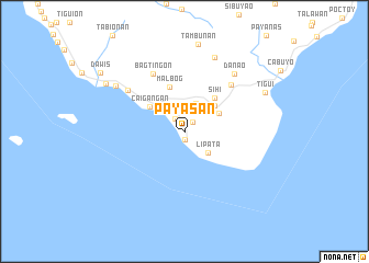
Payasan (Quezon, Philippines)Payasan is a town in the Quezon region of Philippines. An overview map of the region around Payasan is displayed below.
regional and 3d topo map of Payasan, Philippines ::
Payasan airports ::
The nearest airport is MNL - Manila Ninoy Aquino Intl, located 174.3 km north west of Payasan.
Other airports nearby include KLO - Kalibo (177.6 km south), Nearby towns ::
Yook (0.8km south) //
Bagacay (1.3km north east) //
Libas (1.6km north west) //
Sangulong (3.1km north) //
Lipata (3.2km south east) //
Buenavista (3.4km north west) //
Tabuno (3.9km north east) //
Timbo (4.0km north east) //
Caigañgan (4.3km north west) //
Sihi (4.6km north east) //
Malbog (4.7km north) //
Bagtiñgon (6.6km north west) //
Malibago (6.6km north east) //
Daykitin (7.0km north west) //
Danao (7.6km north east) //
Sinambahan (8.1km north) //
Hinubuan (8.2km north west) //
Tig-ui (8.9km north east) //
Banuyo (9.1km north west) //
Dawis (10.2km north west) //
[all distances 'as the bird flies' and approximate] 
Disclaimer :: Information on this page comes without warranty of any kind |
||
|
Where is Payasan? Elevation and coordinates ::
Latitude (lat): 13°14'0"N Longitude (lon): 121°58'0"E
Elevation (approx.): 216m (map arrows pan, magnifying glasses zoom) |
||
|
Visiting Payasan? Hotel/Accommodation ::
Book a hotel in Payasan Travel Guide ::
Buy a travel guide for Philippines rental cars ::
car rental offers GPS waypoint ::
download a GPX waypoint (PoI) of Payasan for your GPS receiver
|
||