|
search place name
|
||
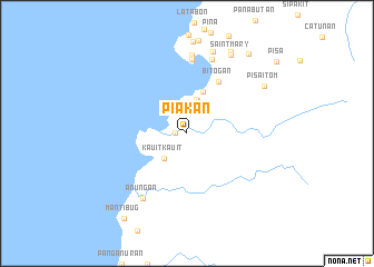
Piakan (Zamboanga del Norte, Philippines)Piakan is a town in the Zamboanga del Norte region of Philippines. An overview map of the region around Piakan is displayed below.
regional and 3d topo map of Piakan, Philippines ::
Piakan airports ::
The nearest airport is ZAM - Zamboanga Intl, located 66.2 km south of Piakan.
Other airports nearby include LGP - Legazpi Pagadian (151.9 km east), DGT - Dumaguete (239.4 km north east), Nearby towns ::
Danganon (1.1km west) //
Bongon (2.5km north) //
Kauit Kauit (3.4km south west) //
Batocan (3.5km north) //
Talabiga (3.6km north) //
Tapanaya (4.5km north) //
Bitogan (6.0km north east) //
Panabutan (7.5km north) //
Anungan (7.8km south west) //
Siraway (7.9km north) //
Macuyon (7.9km north) //
San Roque (8.6km north) //
Saint Mary (9.0km north east) //
Pisa Itom (9.0km north east) //
Makugan (9.3km north east) //
Doña Cecilia (10.1km north east) //
Mantibug (10.6km south west) //
[all distances 'as the bird flies' and approximate] 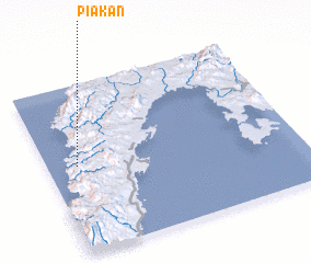 Places with similar names to Piakan, Philippines ::
Disclaimer :: Information on this page comes without warranty of any kind |
||
|
Where is Piakan? Elevation and coordinates ::
Latitude (lat): 7°31'6"N Longitude (lon): 122°7'1"E
Elevation (approx.): 7m (map arrows pan, magnifying glasses zoom) |
||
|
Visiting Piakan? Hotel/Accommodation ::
Book a hotel in Piakan Travel Guide ::
Buy a travel guide for Philippines rental cars ::
car rental offers GPS waypoint ::
download a GPX waypoint (PoI) of Piakan for your GPS receiver
|
||