|
search place name
|
||
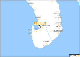
Polillo (Quezon, Philippines)Polillo is a town in the Quezon region of Philippines. An overview map of the region around Polillo is displayed below.
regional and 3d topo map of Polillo, Philippines ::
Polillo airports ::
The nearest airport is MNL - Manila Ninoy Aquino Intl, located 101.6 km west of Polillo.
Other airports nearby include BAG - Baguio (232.1 km north west), Nearby towns ::
Libjo (1.0km south) //
Santa Maria (1.3km north east) //
Lobi (2.1km south west) //
Masisi (2.8km south west) //
Bañadero (3.0km east) //
Sibulan (4.2km north) //
Biguian (4.4km north) //
Bucao (4.4km west) //
Atulayan (4.9km east) //
Sabang (5.3km south west) //
Danao (5.3km south west) //
Bislian (7.6km south) //
Bisliang Munti (8.0km south) //
Anibong (8.3km north) //
Macnit (8.5km east) //
Kolanconan (8.6km east) //
Langoyin (8.6km east) //
Tugpan (9.1km north) //
Canicanian (9.3km north east) //
Canicanian (10.0km north east) //
Bansalaguin (10.3km north east) //
[all distances 'as the bird flies' and approximate] 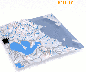 Places with similar names to Polillo, Philippines ::
Disclaimer :: Information on this page comes without warranty of any kind |
||
|
Where is Polillo? Elevation and coordinates ::
Latitude (lat): 14°42'44"N Longitude (lon): 121°56'21"E
Elevation (approx.): 6m (map arrows pan, magnifying glasses zoom) |
||
|
Visiting Polillo? Hotel/Accommodation ::
Book a hotel in Polillo Travel Guide ::
Buy a travel guide for Philippines rental cars ::
car rental offers GPS waypoint ::
download a GPX waypoint (PoI) of Polillo for your GPS receiver
|
||