|
search place name
|
||
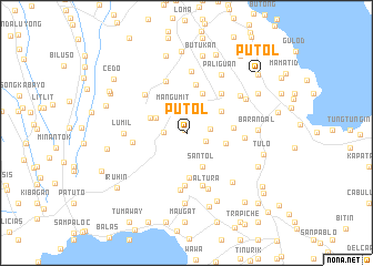
Putol (Laguna, Philippines)Putol is a town in the Laguna region of Philippines. An overview map of the region around Putol is displayed below.
regional and 3d topo map of Putol, Philippines ::
Putol airports ::
The nearest airport is MNL - Manila Ninoy Aquino Intl, located 36.7 km north of Putol.
Nearby towns ::
Balacatac (0.4km north west) //
Laguerta (2.1km south east) //
Buntog (2.2km west) //
Majada (2.4km east) //
Mahabang Pulo (2.7km north east) //
Mangumit (2.8km north west) //
Matang Tubig (3.3km north west) //
Biboyan (3.8km south east) //
Santol (3.8km south east) //
Pittland (3.8km north west) //
Sirang-Lupa (4.0km north east) //
Bubuyan (4.0km east) //
Capatagan (4.3km north) //
Sulpoc (4.5km south) //
Palo Alto (4.6km east) //
Diezmo (5.0km north) //
Tranca (5.3km south) //
Ik-ik (5.3km south) //
Pansol Pugong (5.3km north east) //
Casile (5.3km west) //
Malakingpulo (5.5km south) //
Santo Domingo (5.6km north) //
Puting Kahoy (5.6km north west) //
Montana (5.8km south) //
Punta (5.7km east) //
Altura (6.0km south) //
Numero Dos (6.2km north) //
Lumil (6.2km west) //
Canlubang (6.5km north east) //
[all distances 'as the bird flies' and approximate] 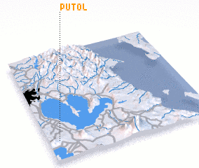 Places with similar names to Putol, Philippines ::
Disclaimer :: Information on this page comes without warranty of any kind |
||
|
Where is Putol? Elevation and coordinates ::
Latitude (lat): 14°10'50"N Longitude (lon): 121°4'6"E
Elevation (approx.): 201m (map arrows pan, magnifying glasses zoom) |
||
|
Visiting Putol? Hotel/Accommodation ::
Book a hotel in Putol Travel Guide ::
Buy a travel guide for Philippines rental cars ::
car rental offers GPS waypoint ::
download a GPX waypoint (PoI) of Putol for your GPS receiver
|
||