|
search place name
|
||
Quinalabasa (Isabela, Philippines)Quinalabasa is a town in the Isabela region of Philippines. An overview map of the region around Quinalabasa is displayed below.
regional and 3d topo map of Quinalabasa, Philippines ::

Quinalabasa airports ::
The nearest airport is BAG - Baguio, located 145.9 km south west of Quinalabasa.
Nearby towns ::
Andrade (2.5km north) //
Cabaruan (4.1km north west) //
Uguep (4.9km north east) //
Manga (4.9km north east) //
Culior (5.4km north) //
Barangin (5.3km west) //
Tierra Virgen (5.6km east) //
Dabburab (5.8km west) //
Cassap (6.0km west) //
Marauiraui (6.3km south) //
San Luis (6.8km north west) //
Malumnim (6.9km north east) //
Nabaculan (7.0km north east) //
Andarayan (6.9km north west) //
Minanga (7.2km north west) //
Cullalabat (7.1km west) //
Nacampegan (7.3km north west) //
Nagbalayan ni Aquinaldo (7.6km east) //
Burgos (8.0km north east) //
Santor-Tungui (8.2km north west) //
Cal-lering (8.2km north west) //
Labinab (8.2km west) //
Bayug (8.6km north) //
Minallo (8.7km north) //
Carabatan (8.4km north west) //
Reina Mercedes (8.8km north west) //
Gappal (9.9km south west) //
Mabantad (9.9km north west) //
Lubub (10.1km south west) //
[all distances 'as the bird flies' and approximate] 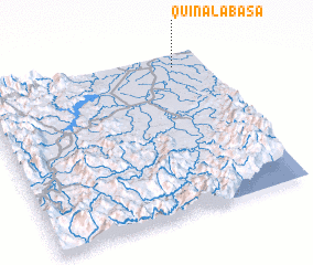 Places with similar names to Quinalabasa, Philippines ::
Disclaimer :: Information on this page comes without warranty of any kind |
||
|
Where is Quinalabasa? Elevation and coordinates ::
Latitude (lat): 16°55'0"N Longitude (lon): 121°52'0"E
Elevation (approx.): 53m (map arrows pan, magnifying glasses zoom) |
||
|
Visiting Quinalabasa? Hotel/Accommodation ::
Book a hotel in Quinalabasa Travel Guide ::
Buy a travel guide for Philippines rental cars ::
car rental offers GPS waypoint ::
download a GPX waypoint (PoI) of Quinalabasa for your GPS receiver
|
||