|
search place name
|
||
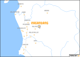
Ragandang (Sultan Kudarat, Philippines)Ragandang is a town in the Sultan Kudarat region of Philippines. An overview map of the region around Ragandang is displayed below.
regional and 3d topo map of Ragandang, Philippines ::
Ragandang airports ::
The nearest airport is CEB - Cebu Cotabato, located 56.5 km north of Ragandang.
Other airports nearby include LGP - Legazpi Pagadian (148.3 km north west), CGY - Ladag Cagayan De Oro (201.3 km north), Nearby towns ::
Nuling (2.3km west) //
Poloy-Poloy (4.0km south west) //
Balila (5.8km south west) //
Barurao (6.0km west) //
Pilandoc (6.2km west) //
Puricay (6.2km north west) //
Lebak (6.5km west) //
Salaman (6.9km south west) //
Kati (7.1km south) //
Basak (8.1km north east) //
Sodoy (8.1km west) //
Tibpuan (8.3km south west) //
Kinudalan (8.5km west) //
Tran (9.9km north west) //
Limulan (10.9km south west) //
[all distances 'as the bird flies' and approximate] 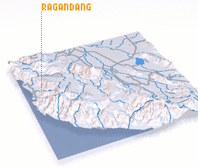 Places with similar names to Ragandang, Philippines :: Disclaimer :: Information on this page comes without warranty of any kind |
||
|
Where is Ragandang? Elevation and coordinates ::
Latitude (lat): 6°39'43"N Longitude (lon): 124°7'20"E
Elevation (approx.): 69m (map arrows pan, magnifying glasses zoom) |
||
|
Visiting Ragandang? Hotel/Accommodation ::
Book a hotel in Ragandang Travel Guide ::
Buy a travel guide for Philippines rental cars ::
car rental offers GPS waypoint ::
download a GPX waypoint (PoI) of Ragandang for your GPS receiver
|
||