|
search place name
|
||
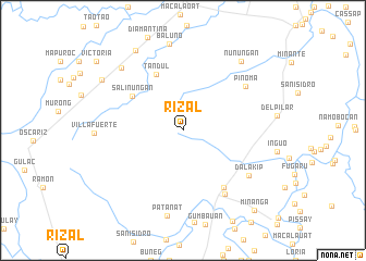
Rizal (Isabela, Philippines)Rizal is a town in the Isabela region of Philippines. An overview map of the region around Rizal is displayed below.
regional and 3d topo map of Rizal, Philippines ::
Rizal airports ::
The nearest airport is BAG - Baguio, located 122.5 km south west of Rizal.
Nearby towns ::
Salinungan (6.1km north west) //
Tandul (6.3km north west) //
Angadanan Viejo (7.1km south east) //
Alicia (7.7km south east) //
Pinoma (7.6km north east) //
Dalakip (7.9km south east) //
Patanat (8.9km south) //
Daramuangan Sur (8.9km north west) //
Nunuñgan (9.1km north east) //
Marasat Pequeño (9.5km north west) //
San Mateo (9.5km north west) //
Minanga (10.7km south east) //
Daramuangan Norte (11.0km north west) //
Victoria (11.0km north west) //
[all distances 'as the bird flies' and approximate] 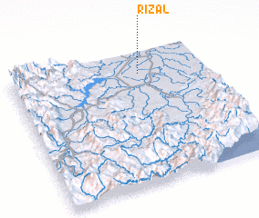 Places with similar names to Rizal, Philippines ::
Disclaimer :: Information on this page comes without warranty of any kind |
||
|
Where is Rizal? Elevation and coordinates ::
Latitude (lat): 16°50'11"N Longitude (lon): 121°39'46"E
Elevation (approx.): 72m (map arrows pan, magnifying glasses zoom) |
||
|
Visiting Rizal? Hotel/Accommodation ::
Book a hotel in Rizal Travel Guide ::
Buy a travel guide for Philippines rental cars ::
car rental offers GPS waypoint ::
download a GPX waypoint (PoI) of Rizal for your GPS receiver
|
||