|
search place name
|
||
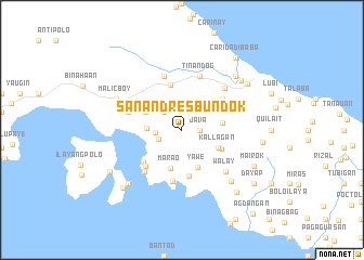
San Andres Bundok (Quezon, Philippines)San Andres Bundok is a town in the Quezon region of Philippines. An overview map of the region around San Andres Bundok is displayed below.
regional and 3d topo map of San Andres Bundok, Philippines ::
San Andres Bundok airports ::
The nearest airport is MNL - Manila Ninoy Aquino Intl, located 108.9 km north west of San Andres Bundok.
Nearby towns ::
Java (1.8km east) //
San Andres Labak (1.8km east) //
Vargas (2.6km north west) //
Cabog (2.6km west) //
Hinguiwin (2.7km west) //
Sipa (3.5km west) //
Yawe (4.1km south east) //
Palapas (4.0km north west) //
Kallagan (4.0km south east) //
Marao (4.2km south) //
Montes (4.2km east) //
Duhat (4.4km south east) //
Baisong (4.7km south) //
Sokol (4.8km north) //
Padre Burgos (5.1km south west) //
Kinagunan (5.2km south west) //
San Isidro (5.2km south west) //
Marquez (5.2km south west) //
Sapaan (5.2km north east) //
Danlagan (5.4km south) //
Basiao (5.7km south west) //
Malinao Ibaba (5.8km north) //
Malinao Ilaya (5.8km north) //
Santa Catalina (5.8km north) //
Usllya (5.7km west) //
Rizal (5.8km north) //
Tinandog (5.8km north) //
San Isidro (6.1km north east) //
Walay (6.2km south east) //
[all distances 'as the bird flies' and approximate]  Places with similar names to San Andres Bundok, Philippines :: Disclaimer :: Information on this page comes without warranty of any kind |
||
|
Where is San Andres Bundok? Elevation and coordinates ::
Latitude (lat): 13°57'0"N Longitude (lon): 121°51'0"E
Elevation (approx.): 169m (map arrows pan, magnifying glasses zoom) |
||
|
Visiting San Andres Bundok? Hotel/Accommodation ::
Book a hotel in San Andres Bundok Travel Guide ::
Buy a travel guide for Philippines rental cars ::
car rental offers GPS waypoint ::
download a GPX waypoint (PoI) of San Andres Bundok for your GPS receiver
|
||