|
search place name
|
||
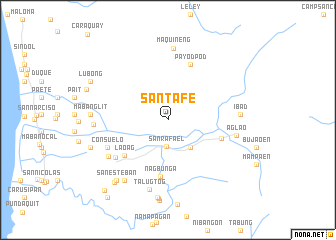
Santa Fe (Zambales, Philippines)Santa Fe is a town in the Zambales region of Philippines. An overview map of the region around Santa Fe is displayed below.
regional and 3d topo map of Santa Fe, Philippines ::
Santa Fe airports ::
The nearest airport is MNL - Manila Ninoy Aquino Intl, located 103.3 km south east of Santa Fe.
Other airports nearby include BAG - Baguio (157.2 km north), Nearby towns ::
San Rafael (3.0km south) //
Nagbayto (3.9km south east) //
Laoag (6.1km south west) //
Dalanaoan (6.1km east) //
Nagbuñga (6.3km south) //
Payodpod (6.6km north) //
San Marcelino (7.0km south west) //
Consuelo (7.2km south west) //
Linasin (7.6km south west) //
Aglao (7.6km east) //
Talugtog (8.0km south) //
Maquineng (8.1km north) //
Ibad (7.8km east) //
Umaya (8.0km west) //
Nabuñga (8.3km south west) //
Mabanglit (8.3km west) //
Tondo (8.7km south) //
San Esteban (8.7km south west) //
Santa Maria (8.9km south) //
Nagsabong (8.9km west) //
Linosuñgan (9.1km south west) //
Lubong (9.4km north west) //
San Antonio (10.5km south west) //
San Agustin (10.8km south west) //
[all distances 'as the bird flies' and approximate] 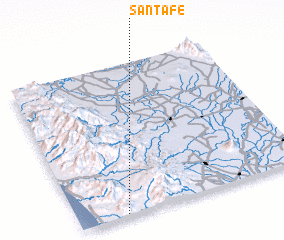 Places with similar names to Santa Fe, Philippines ::
Disclaimer :: Information on this page comes without warranty of any kind |
||
|
Where is Santa Fe? Elevation and coordinates ::
Latitude (lat): 15°0'40"N Longitude (lon): 120°12'39"E
Elevation (approx.): 83m (map arrows pan, magnifying glasses zoom) |
||
|
Visiting Santa Fe? Hotel/Accommodation ::
Book a hotel in Santa Fe Travel Guide ::
Buy a travel guide for Philippines rental cars ::
car rental offers GPS waypoint ::
download a GPX waypoint (PoI) of Santa Fe for your GPS receiver
|
||