|
search place name
|
||
Si Abon (Tawi-Tawi, Philippines)Si Abon is a town in the Tawi-Tawi region of Philippines. An overview map of the region around Si Abon is displayed below.
regional and 3d topo map of Si Abon, Philippines ::
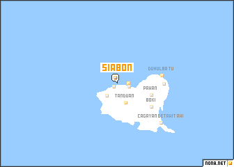
Nearby towns ::
Kaumpang (0.7km south west) //
Anibun (1.8km east) //
Ungus Mataha (2.0km east) //
Si Kub (2.6km south west) //
Tandu'an (3.4km south east) //
Pawan (5.8km east) //
Boki” (6.6km south east) //
Duhul Batu (7.2km east) //
Gĕppá (7.4km east) //
Cagayan de Tawi-Tawi (9.4km south east) //
[all distances 'as the bird flies' and approximate]  Places with similar names to Si Abon, Philippines ::
Disclaimer :: Information on this page comes without warranty of any kind |
||
|
Where is Si Abon? Elevation and coordinates ::
Latitude (lat): 7°2'0"N Longitude (lon): 118°27'0"E
Elevation (approx.): 114m (map arrows pan, magnifying glasses zoom) |
||
|
Visiting Si Abon? Hotel/Accommodation ::
Book a hotel in Si Abon Travel Guide ::
Buy a travel guide for Philippines rental cars ::
car rental offers GPS waypoint ::
download a GPX waypoint (PoI) of Si Abon for your GPS receiver
|
||