|
search place name
|
||
Tacadang (Benguet, Philippines)Tacadang is a town in the Benguet region of Philippines. An overview map of the region around Tacadang is displayed below.
regional and 3d topo map of Tacadang, Philippines ::

Tacadang airports ::
The nearest airport is BAG - Baguio, located 36.1 km south of Tacadang.
Nearby towns ::
Kibuñgan (1.1km east) //
Sagubo (2.6km south east) //
Amsuling (4.1km south east) //
Lobo (5.1km south east) //
Palina (6.6km north east) //
Napsong (6.5km north east) //
Pangpang (6.8km north east) //
Malyeng (7.6km north) //
Legleg (7.6km south) //
Balakbak (8.1km south) //
Cuba (8.7km south) //
Dalipey (10.2km north west) //
Liaong (10.3km north east) //
Cayabayan (10.3km north east) //
[all distances 'as the bird flies' and approximate] 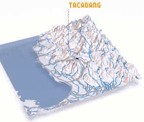 Places with similar names to Tacadang, Philippines ::
// Togotenga (BF)
// Tougatenga (BF)
// Touka Dionga (BF)
// Tucutinca (CO)
// Dikadungu (CD)
// Dago Tengah (ID)
// Dukuhtengah (ID)
// Takudung (ID)
// Tukudung (SD)
// Dek-Donak (TJ)
Disclaimer :: Information on this page comes without warranty of any kind |
||
|
Where is Tacadang? Elevation and coordinates ::
Latitude (lat): 16°42'0"N Longitude (lon): 120°39'0"E
Elevation (approx.): 1052m (map arrows pan, magnifying glasses zoom) |
||
|
Visiting Tacadang? Hotel/Accommodation ::
Book a hotel in Tacadang Travel Guide ::
Buy a travel guide for Philippines rental cars ::
car rental offers GPS waypoint ::
download a GPX waypoint (PoI) of Tacadang for your GPS receiver
|
||