|
search place name
|
||
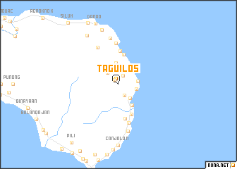
Taguilos (Romblon, Philippines)Taguilos is a town in the Romblon region of Philippines. An overview map of the region around Taguilos is displayed below.
regional and 3d topo map of Taguilos, Philippines ::
Taguilos airports ::
The nearest airport is KLO - Kalibo, located 85.8 km south of Taguilos.
Other airports nearby include ILO - Iloilo (187.1 km south), BCD - Bacolod (196.5 km south), SJI - San Jose Antique (197.6 km south west), Nearby towns ::
Wala (0.9km north west) //
Incodbato (1.6km north east) //
Taguan (1.9km south east) //
Lumbang (2.2km north) //
To-o (2.4km north west) //
Lico (2.4km north west) //
Sugod (2.9km south east) //
Gutivan (2.9km east) //
Cambulayan (3.0km east) //
Cambijang (3.3km north east) //
Tubuyan (3.5km north) //
Cajidiocan (3.9km south east) //
Marigondon (4.9km north) //
Cambajao (5.1km south east) //
Talirao (5.3km north) //
Alibangon (5.5km south) //
Cambijang (6.3km south) //
Magbagacay (6.6km north) //
Cambalo (6.6km north west) //
Catmon (7.4km north) //
Candayaga (7.6km south) //
Talongon (9.0km north) //
Camanglad (9.2km north west) //
[all distances 'as the bird flies' and approximate] 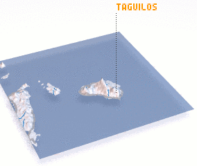 Places with similar names to Taguilos, Philippines ::
Disclaimer :: Information on this page comes without warranty of any kind |
||
|
Where is Taguilos? Elevation and coordinates ::
Latitude (lat): 12°24'0"N Longitude (lon): 122°40'0"E
Elevation (approx.): 250m (map arrows pan, magnifying glasses zoom) |
||
|
Visiting Taguilos? Hotel/Accommodation ::
Book a hotel in Taguilos Travel Guide ::
Buy a travel guide for Philippines rental cars ::
car rental offers GPS waypoint ::
download a GPX waypoint (PoI) of Taguilos for your GPS receiver
|
||