|
search place name
|
||
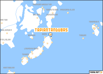
Tapian Tandu Bas (Tawi-Tawi, Philippines)Tapian Tandu Bas is a town in the Tawi-Tawi region of Philippines. An overview map of the region around Tapian Tandu Bas is displayed below.
regional and 3d topo map of Tapian Tandu Bas, Philippines ::
Tapian Tandu Bas airports ::
The nearest airport is ZAM - Zamboanga Intl, located 272.4 km north east of Tapian Tandu Bas.
Nearby towns ::
Bellak (0.3km south) //
Tandubas (0.9km north west) //
Ungus Matata (2.0km south) //
Sapa (2.4km west) //
Tandu Batu (2.7km south west) //
Sallangan (3.3km south west) //
Kohek (4.6km south west) //
Look Nato (5.9km south west) //
Dundangan (7.0km north) //
Batan (7.0km north) //
Ba”uwan (7.0km west) //
Malanta (7.3km south west) //
Galaan (8.6km north west) //
Toong Toong (8.8km north) //
Laum Sikubung (8.9km south west) //
Likud Sikubung (9.2km south west) //
Si Kubung Tausan (9.2km south west) //
Langaray (9.2km south west) //
Pasigan de Lea (10.6km north east) //
Sokah-Sokah (10.6km south west) //
Sapa-Sapa (10.8km south west) //
Tungal (11.8km south west) //
[all distances 'as the bird flies' and approximate] 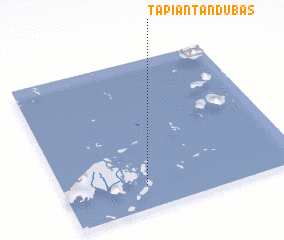 Places with similar names to Tapian Tandu Bas, Philippines :: Disclaimer :: Information on this page comes without warranty of any kind |
||
|
Where is Tapian Tandu Bas? Elevation and coordinates ::
Latitude (lat): 5°9'15"N Longitude (lon): 120°20'47"E
(map arrows pan, magnifying glasses zoom) |
||
|
Visiting Tapian Tandu Bas? Hotel/Accommodation ::
Book a hotel in Tapian Tandu Bas Travel Guide ::
Buy a travel guide for Philippines rental cars ::
car rental offers GPS waypoint ::
download a GPX waypoint (PoI) of Tapian Tandu Bas for your GPS receiver
|
||