|
search place name
|
||
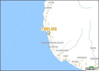
Tarling (Zamboanga del Sur, Philippines)Tarling is a town in the Zamboanga del Sur region of Philippines. An overview map of the region around Tarling is displayed below.
regional and 3d topo map of Tarling, Philippines ::
Tarling airports ::
The nearest airport is ZAM - Zamboanga Intl, located 20.1 km south east of Tarling.
Other airports nearby include LGP - Legazpi Pagadian (191.5 km north east), Nearby towns ::
Tinuba (0.4km south east) //
Sinubong (1.2km south east) //
Lubugan (1.8km south) //
San Ramon Penal Colony (3.8km south) //
Balicagas (4.4km north) //
Talisayan (5.3km south) //
Patalon (5.8km north) //
Lawingan (6.4km north) //
Labuan (7.4km north) //
Domasa (7.9km south east) //
Tulungatung (8.1km south east) //
Cadalagan (8.4km south east) //
Tuburan (8.6km north) //
Ayala (9.2km south east) //
Cawit (10.6km south east) //
[all distances 'as the bird flies' and approximate]  Places with similar names to Tarling, Philippines ::
Disclaimer :: Information on this page comes without warranty of any kind |
||
|
Where is Tarling? Elevation and coordinates ::
Latitude (lat): 7°2'2"N Longitude (lon): 121°54'58"E
Elevation (approx.): 25m (map arrows pan, magnifying glasses zoom) |
||
|
Visiting Tarling? Hotel/Accommodation ::
Book a hotel in Tarling Travel Guide ::
Buy a travel guide for Philippines rental cars ::
car rental offers GPS waypoint ::
download a GPX waypoint (PoI) of Tarling for your GPS receiver
|
||