|
search place name
|
||
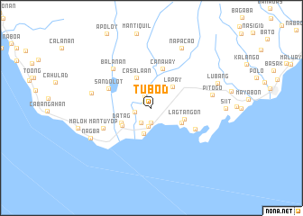
Tubod (Negros Oriental, Philippines)Tubod is a town in the Negros Oriental region of Philippines. An overview map of the region around Tubod is displayed below.
regional and 3d topo map of Tubod, Philippines ::
Tubod airports ::
The nearest airport is DGT - Dumaguete, located 37.8 km north east of Tubod.
Other airports nearby include LGP - Legazpi Pagadian (145.5 km south), NOP - Masbate Mactan Cebu Intl (168.4 km north east), BCD - Bacolod (173.1 km north), CGY - Ladag Cagayan De Oro (185.3 km south east), Nearby towns ::
Tayac (1.1km north west) //
Balayan Olang (1.8km north west) //
Canaway (1.9km south) //
Camboay (2.1km west) //
Inalad (2.2km south west) //
Sumaliring (2.3km south) //
Balogo (3.3km south) //
Lapay (3.6km north east) //
Agbagacay (4.1km south east) //
Albiga (4.1km south east) //
Datag (4.1km south west) //
Casala-an (4.1km north west) //
Siaton (4.2km south west) //
Lagtangon (4.2km east) //
Canaway (5.0km north) //
Sandolot (5.7km north west) //
Bonbonon (6.0km south east) //
Mantuyop (6.4km south west) //
Balanan (6.7km north west) //
Caticugan (7.6km west) //
Pitogo (7.6km east) //
Napacao (8.3km north east) //
Nagba (8.3km south west) //
Lubang (8.7km east) //
[all distances 'as the bird flies' and approximate] 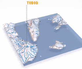 Places with similar names to Tubod, Philippines ::
Disclaimer :: Information on this page comes without warranty of any kind |
||
|
Where is Tubod? Elevation and coordinates ::
Latitude (lat): 9°5'0"N Longitude (lon): 123°4'0"E
Elevation (approx.): 49m (map arrows pan, magnifying glasses zoom) |
||
|
Visiting Tubod? Hotel/Accommodation ::
Book a hotel in Tubod Travel Guide ::
Buy a travel guide for Philippines rental cars ::
car rental offers GPS waypoint ::
download a GPX waypoint (PoI) of Tubod for your GPS receiver
|
||