|
search place name
|
||
Tuguib (Abra, Philippines)Tuguib is a town in the Abra region of Philippines. An overview map of the region around Tuguib is displayed below.
regional and 3d topo map of Tuguib, Philippines ::

Tuguib airports ::
The nearest airport is BAG - Baguio, located 113.4 km south of Tuguib.
Nearby towns ::
Tuquib-Cal-lao (0.5km north west) //
Denden (1.9km north) //
Bangal (2.6km north east) //
Callao (3.0km north east) //
Apapaya (3.7km north) //
Bolbolala (3.7km north) //
Narnara (3.5km west) //
San Juan (3.7km west) //
Palicad (4.1km north west) //
Kinaviti (4.0km south west) //
San Juan (4.0km south west) //
Balioag Norte (4.0km north west) //
Villaviciosa (4.2km north) //
Pilar (4.6km north west) //
Bolbolo (4.7km south west) //
Madangdangla (5.3km east) //
South Balioag (5.3km west) //
Liogan (5.3km east) //
Anopol (5.3km east) //
Santo Tomas (5.8km north) //
Ul-ulingen (5.8km north) //
Apa-apaya (5.8km north) //
Bato (5.6km west) //
Barit (5.6km east) //
Barrit (5.6km east) //
San Pedro (5.6km east) //
Tilong (5.6km east) //
Tiquitic (5.6km west) //
Maliplipit (5.6km west) //
[all distances 'as the bird flies' and approximate] 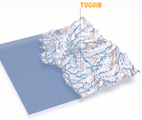 Places with similar names to Tuguib, Philippines ::
Disclaimer :: Information on this page comes without warranty of any kind |
||
|
Where is Tuguib? Elevation and coordinates ::
Latitude (lat): 17°24'0"N Longitude (lon): 120°38'0"E
Elevation (approx.): 486m (map arrows pan, magnifying glasses zoom) |
||
|
Visiting Tuguib? Hotel/Accommodation ::
Book a hotel in Tuguib Travel Guide ::
Buy a travel guide for Philippines rental cars ::
car rental offers GPS waypoint ::
download a GPX waypoint (PoI) of Tuguib for your GPS receiver
|
||