|
search place name
|
||
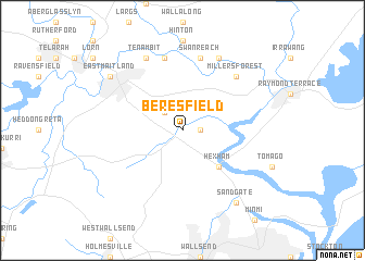
Beresfield (New South Wales, Australia)Beresfield is a town in the New South Wales region of Australia. An overview map of the region around Beresfield is displayed below.
regional and 3d topo map of Beresfield, Australia ::
Beresfield airports ::
The nearest airport is RCM - Richmond, located 120.2 km south west of Beresfield.
Other airports nearby include SYD - Sydney Intl (134.5 km south), BWU - Sydney Bankstown (139.1 km south west), CDU - Camden (164.1 km south west), TMW - Tamworth (204.9 km north), Nearby towns ::
Tarro (1.6km east) //
Thornton (2.4km north west) //
Hexham (4.8km south east) //
Swan Reach (7.6km north) //
Morpeth (7.6km north) //
Berry Park (7.6km north) //
Millers Forest (7.3km north east) //
Duckenfield (8.0km north east) //
Raworth (8.0km north west) //
Tenambit (8.0km north west) //
Sandgate (8.8km south east) //
East Maitland (8.4km north west) //
[all distances 'as the bird flies' and approximate] 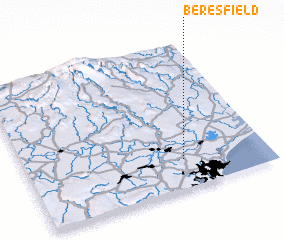 Places with similar names to Beresfield, Australia ::
// Brasfield (US)
// Bursfelde (DE)
// Bracefield (ZA)
// Brassfield (US)
// Brassfield (US)
// Brucefield (JM)
// Bruceville-Eddy (US)
// Brucefield (AU)
Disclaimer :: Information on this page comes without warranty of any kind |
||
|
Where is Beresfield? Elevation and coordinates ::
Latitude (lat): 32°48'0"S Longitude (lon): 151°39'0"E
Elevation (approx.): 22m (map arrows pan, magnifying glasses zoom) |
||
|
Visiting Beresfield? Hotel/Accommodation ::
Book a hotel in Beresfield Travel Guide ::
Buy a travel guide for Australia rental cars ::
car rental offers GPS waypoint ::
download a GPX waypoint (PoI) of Beresfield for your GPS receiver
|
||