|
search place name
|
||
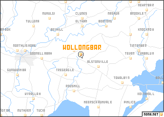
Wollongbar (New South Wales, Australia)Wollongbar is a town in the New South Wales region of Australia. An overview map of the region around Wollongbar is displayed below.
regional and 3d topo map of Wollongbar, Australia ::
Wollongbar airports ::
The nearest airport is OOL - Coolangatta Gold Coast, located 73.0 km north of Wollongbar.
Other airports nearby include BNE - Brisbane Intl (161.2 km north), CFS - Coff's Harbour Coffs Harbour (168.9 km south), Nearby towns ::
McLeans Ridges (2.5km north west) //
Alstonville (3.7km south east) //
Tregeagle (4.9km south west) //
Eltham (7.4km north) //
Rous Mill (7.6km south) //
Bexhill (7.4km north west) //
Booyong (8.9km north east) //
[all distances 'as the bird flies' and approximate] 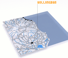 Places with similar names to Wollongbar, Australia ::
// Willingboro (US)
Disclaimer :: Information on this page comes without warranty of any kind |
||
|
Where is Wollongbar? Elevation and coordinates ::
Latitude (lat): 28°49'0"S Longitude (lon): 153°24'0"E
Elevation (approx.): 171m (map arrows pan, magnifying glasses zoom) |
||
|
Visiting Wollongbar? Hotel/Accommodation ::
Book a hotel in Wollongbar Travel Guide ::
Buy a travel guide for Australia rental cars ::
car rental offers GPS waypoint ::
download a GPX waypoint (PoI) of Wollongbar for your GPS receiver
|
||