|
search place name
|
||
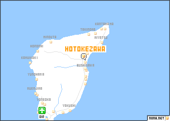
Hotokezawa (Hokkaidō, Japan)Hotokezawa is a town in the Hokkaidō region of Japan. An overview map of the region around Hotokezawa is displayed below.
regional and 3d topo map of Hotokezawa, Japan ::
Hotokezawa airports ::
The nearest airport is OIR - Okushiri, located 13.2 km south west of Hotokezawa.
Other airports nearby include HKD - Hakodate (116.9 km east), SPK - Sapporo (185.3 km north east), AOJ - Aomori (187.3 km south east), MSJ - Misawa Ab (224.7 km south east), Nearby towns ::
Okushiri (0.4km south) //
Tamaura (1.6km north) //
Yachi (1.9km south) //
Bushigawa (2.2km south) //
Yamasedomari (2.9km north east) //
Akaishi (3.5km south) //
Yamagamisaki (4.1km south) //
Onkouta (5.2km south) //
Miyatsu (4.8km north east) //
Takinoma (5.8km north) //
Nonamae (6.2km north) //
Inaho (7.5km north) //
Kantahama (7.7km north east) //
Minouta (6.9km north west) //
[all distances 'as the bird flies' and approximate] 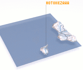 Places with similar names to Hotokezawa, Japan :: Disclaimer :: Information on this page comes without warranty of any kind |
||
|
Where is Hotokezawa? Elevation and coordinates ::
Latitude (lat): 42°10'18"N Longitude (lon): 139°31'5"E
Elevation (approx.): -32768m (map arrows pan, magnifying glasses zoom) |
||
|
Visiting Hotokezawa? Hotel/Accommodation ::
Book a hotel in Hotokezawa Travel Guide ::
Buy a travel guide for Japan rental cars ::
car rental offers GPS waypoint ::
download a GPX waypoint (PoI) of Hotokezawa for your GPS receiver
|
||