|
search place name
|
||
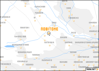
Nobitome (Saitama, Japan)Nobitome is a town in the Saitama region of Japan. An overview map of the region around Nobitome is displayed below.
regional and 3d topo map of Nobitome, Japan ::
Nobitome airports ::
The nearest airport is OKO - Yokota Ab, located 20.5 km west of Nobitome.
Other airports nearby include HND - Tokyo Intl (33.6 km south east), NRT - Tokyo Narita Intl (74.2 km east), OIM - Oshima (114.5 km south), MMJ - Matsumoto (153.7 km west), Nearby towns ::
Ōwada (1.5km west) //
Sugasawa (2.4km south west) //
Katayama (3.7km south) //
Shiki (4.0km north) //
Niikura (4.9km east) //
Ōi (7.3km north west) //
Shirako (7.1km south east) //
Fukuoka (8.0km north) //
Tanashi (9.4km south west) //
Harigayachō (9.5km north east) //
Urawa (10.4km north east) //
[all distances 'as the bird flies' and approximate] 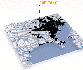 Places with similar names to Nobitome, Japan ::
// Nboutoum (CM)
// Nowy Bytom (PL)
// Nabitama (UG)
// Nboutembou (SN)
// Nabatum (NG)
// Nabatum (NG)
Disclaimer :: Information on this page comes without warranty of any kind |
||
|
Where is Nobitome? Elevation and coordinates ::
Latitude (lat): 35°48'0"N Longitude (lon): 139°34'0"E
Elevation (approx.): 38m (map arrows pan, magnifying glasses zoom) |
||
|
Visiting Nobitome? Hotel/Accommodation ::
Book a hotel in Nobitome Travel Guide ::
Buy a travel guide for Japan rental cars ::
car rental offers GPS waypoint ::
download a GPX waypoint (PoI) of Nobitome for your GPS receiver
|
||