|
search place name
|
||
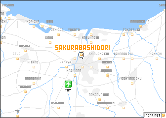
Sakurabashidōri (Toyama, Japan)Sakurabashidōri is a town in the Toyama region of Japan. An overview map of the region around Sakurabashidōri is displayed below.
regional and 3d topo map of Sakurabashidōri, Japan ::
Sakurabashidōri airports ::
The nearest airport is TOY - Toyama, located 6.3 km south west of Sakurabashidōri.
Other airports nearby include KMQ - Kanazawa Komatsu (80.1 km south west), MMJ - Matsumoto (86.7 km south east), ITM - Osaka Intl (266.4 km south west), Nearby towns ::
Nakajima (1.9km north) //
Toyama (1.9km south) //
Omotemachi (1.5km west) //
Shin-sōgawa (1.5km west) //
Ishigane (2.4km south east) //
Irifunemachi (2.4km north west) //
Shinjōmachi (3.0km east) //
Hasumachi (4.0km north) //
Hagiwara (4.0km south) //
Kanaya (3.5km south west) //
Higashi-iwase (5.8km north) //
Nishinomiya (5.8km north) //
Kitadai (4.8km north west) //
Yokata (5.8km north) //
Hiraki (4.8km south east) //
Ōshima (5.8km south east) //
Ashiarai (7.1km north west) //
Kamo (7.0km north west) //
Ebie (9.5km north west) //
[all distances 'as the bird flies' and approximate]  Places with similar names to Sakurabashidōri, Japan :: Disclaimer :: Information on this page comes without warranty of any kind |
||
|
Where is Sakurabashidōri? Elevation and coordinates ::
Latitude (lat): 36°42'0"N Longitude (lon): 137°13'0"E
Elevation (approx.): 12m (map arrows pan, magnifying glasses zoom) |
||
|
Visiting Sakurabashidōri? Hotel/Accommodation ::
Book a hotel in Sakurabashidōri Travel Guide ::
Buy a travel guide for Japan rental cars ::
car rental offers GPS waypoint ::
download a GPX waypoint (PoI) of Sakurabashidōri for your GPS receiver
|
||