|
search place name
|
||
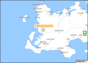
Tamanoura (Nagasaki, Japan)Tamanoura is a town in the Nagasaki region of Japan. An overview map of the region around Tamanoura is displayed below.
regional and 3d topo map of Tamanoura, Japan ::
Tamanoura airports ::
The nearest airport is FUJ - Fukue, located 14.8 km east of Tamanoura.
Other airports nearby include NGS - Nagasaki (119.2 km east), IKI - Iki (158.1 km north east), TSJ - Tsushima (189.1 km north), FUK - Fukuoka (194.3 km north east), Nearby towns ::
Tanna (0.8km west) //
Arakawa (1.5km south) //
Ikkuyama (4.8km south east) //
Nakasu (5.3km south) //
Kaitsu (5.5km north west) //
Ogawa (6.1km south) //
Nihongusu (5.5km east) //
Hasama (7.7km north) //
Miraku (7.8km north) //
Daihō (8.1km south) //
Shiroishi (8.7km north) //
Hamanokuri (8.8km north) //
Ushinoura (9.0km north) //
Kawara (8.8km north east) //
Saganoshima (8.6km north west) //
Kurose (9.9km south east) //
[all distances 'as the bird flies' and approximate]  Places with similar names to Tamanoura, Japan ::
// Tumanur (RU)
// Hyde Manor (US)
// Temnaoré (BF)
// Tèmnoré (BF)
// Temnoré (BF)
// Tamnar (IN)
// Tumnar (IN)
// Doumana Ara (NE)
// Timinar (SD)
// Damner (PK)
Disclaimer :: Information on this page comes without warranty of any kind |
||
|
Where is Tamanoura? Elevation and coordinates ::
Latitude (lat): 32°40'17"N Longitude (lon): 128°40'29"E
Elevation (approx.): -32768m (map arrows pan, magnifying glasses zoom) |
||
|
Visiting Tamanoura? Hotel/Accommodation ::
Book a hotel in Tamanoura Travel Guide ::
Buy a travel guide for Japan rental cars ::
car rental offers GPS waypoint ::
download a GPX waypoint (PoI) of Tamanoura for your GPS receiver
|
||