|
search place name
|
||
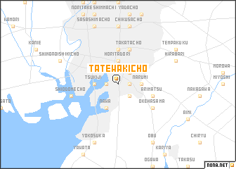
Tatewakichō (Aichi, Japan)Tatewakichō is a town in the Aichi region of Japan. An overview map of the region around Tatewakichō is displayed below.
regional and 3d topo map of Tatewakichō, Japan ::
Tatewakichō airports ::
The nearest airport is ITM - Osaka Intl, located 139.1 km west of Tatewakichō.
Other airports nearby include MMJ - Matsumoto (150.8 km north east), KMQ - Kanazawa Komatsu (152.6 km north), TOY - Toyama (175.4 km north), SHM - Nanki-shirahama Nanki Shirahama (212.7 km south west), Nearby towns ::
Hoshizakichō (1.5km east) //
Ōechō (1.5km west) //
Ōdaka (2.4km south east) //
Suishachō (2.4km north east) //
Narumi (3.0km east) //
Denjiyama (3.0km east) //
Tsukiji (3.0km west) //
Horitadōri (3.7km north) //
Hamachō (3.0km west) //
Minato-hommachi (3.0km west) //
Nawa (4.0km south) //
Mutsunochō (5.6km north) //
Arimatsu (4.9km east) //
Takatachō (5.8km north) //
Okehasama (5.9km south east) //
Shiodomechō (6.3km west) //
[all distances 'as the bird flies' and approximate] 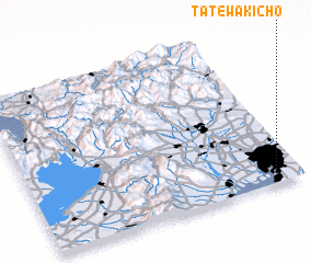 Places with similar names to Tatewakichō, Japan :: Disclaimer :: Information on this page comes without warranty of any kind |
||
|
Where is Tatewakichō? Elevation and coordinates ::
Latitude (lat): 35°5'0"N Longitude (lon): 136°55'0"E
Elevation (approx.): -1m (map arrows pan, magnifying glasses zoom) |
||
|
Visiting Tatewakichō? Hotel/Accommodation ::
Book a hotel in Tatewakichō Travel Guide ::
Buy a travel guide for Japan rental cars ::
car rental offers GPS waypoint ::
download a GPX waypoint (PoI) of Tatewakichō for your GPS receiver
|
||