|
search place name
|
||
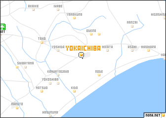
Yōkaichiba (Chiba, Japan)Yōkaichiba is a town in the Chiba region of Japan. An overview map of the region around Yōkaichiba is displayed below.
regional and 3d topo map of Yōkaichiba, Japan ::
Yōkaichiba airports ::
The nearest airport is NRT - Tokyo Narita Intl, located 16.5 km north west of Yōkaichiba.
Other airports nearby include HND - Tokyo Intl (71.7 km west), OKO - Yokota Ab (108.8 km west), OIM - Oshima (148.7 km south west), MMY - Miyake Jima Miyakejima (201.8 km south west), Nearby towns ::
Tsubaki (2.4km north east) //
Node (4.8km south east) //
Hikata (4.9km east) //
Ōdera (5.8km north) //
Yoshida (4.9km west) //
Kaburagi (6.3km north east) //
Kami-miyagawa (5.8km south west) //
Kido (7.6km south) //
Miyagawa (7.2km south west) //
Yokoshiba (8.2km south west) //
[all distances 'as the bird flies' and approximate] 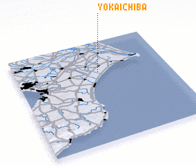
Disclaimer :: Information on this page comes without warranty of any kind |
||
|
Where is Yōkaichiba? Elevation and coordinates ::
Latitude (lat): 35°42'0"N Longitude (lon): 140°33'0"E
Elevation (approx.): 10m (map arrows pan, magnifying glasses zoom) |
||
|
Visiting Yōkaichiba? Hotel/Accommodation ::
Book a hotel in Yōkaichiba Travel Guide ::
Buy a travel guide for Japan rental cars ::
car rental offers GPS waypoint ::
download a GPX waypoint (PoI) of Yōkaichiba for your GPS receiver
|
||