|
search place name
|
||
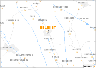
Selemet (Raionul )) (( Anenii Noi, Moldova)Selemet is a town in the Raionul )) (( Anenii Noi region of Moldova. An overview map of the region around Selemet is displayed below.
regional and 3d topo map of Selemet, Moldova ::
Selemet airports ::
The nearest airport is KIV - Kichinau Fir/acc/com Chisinau Intl, located 38.9 km north of Selemet.
Other airports nearby include IAS - Iasi (119.9 km north west), ODS - Odessa Odesa Intl (135.4 km east), TCE - Tulcea Cataloi (169.2 km south), Nearby towns ::
Mihailovca (3.0km south) //
Satul Nou (4.7km north) //
Bogdanovca (7.3km south) //
Suric (7.0km north west) //
Ivanovca (8.1km south) //
Batîr (5.9km east) //
Ciufleşti (7.7km north east) //
[all distances 'as the bird flies' and approximate]  Places with similar names to Selemet, Moldova ::
// Solomáta (GR)
// Selâmet (TR)
// Sulumita (TR)
// Şāliḩ Mahdī (IQ)
// Zulaymāt (IQ)
// Slim Butte (US)
// Sālamdi (BD)
// Selāmati (BD)
// Salamata (TD)
// Salomita (CO)
Disclaimer :: Information on this page comes without warranty of any kind |
||
|
Where is Selemet? Elevation and coordinates ::
Latitude (lat): 46°34'40"N Longitude (lon): 28°55'35"E
Elevation (approx.): 108m (map arrows pan, magnifying glasses zoom) |
||
|
Visiting Selemet? Hotel/Accommodation ::
Book a hotel in Selemet Travel Guide ::
Buy a travel guide for Moldova rental cars ::
car rental offers GPS waypoint ::
download a GPX waypoint (PoI) of Selemet for your GPS receiver
|
||