|
search place name
|
||
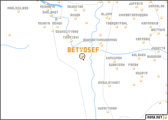
Bet Yosef (HaẔafon, Israel)Bet Yosef is a town in the HaẔafon region of Israel. An overview map of the region around Bet Yosef is displayed below.
regional and 3d topo map of Bet Yosef, Israel ::
Bet Yosef airports ::
The nearest airport is ADJ - Amman Marka Intl, located 61.7 km south east of Bet Yosef.
Other airports nearby include RPN - Rosh Pina Mahanaim I Ben Yaakov (66.3 km north), OMF - Mafraq King Hussein (66.8 km east), HFA - Haifa (67.1 km north west), TLV - Tel-aviv Ben Gurion (74.9 km south west), Nearby towns ::
Tirat Ẕevi (4.9km north west) //
Al Mazra‘ (4.7km north east) //
Ash Shaykh Muḩammad (4.9km north east) //
Sede Eliyyahu (6.4km north west) //
Khirbat ash Shaykh Muḩammad (6.4km north east) //
Kurkumah (5.7km east) //
Subayrah (6.5km east) //
As Sulaykhāt (7.6km south east) //
Kefar Ruppin (8.2km north) //
Reẖov (8.9km north west) //
Sede Terumot (8.7km north west) //
Ţabaqat Faḩl (9.7km north east) //
Rewaya (10.5km north west) //
[all distances 'as the bird flies' and approximate]  Places with similar names to Bet Yosef, Israel :: Disclaimer :: Information on this page comes without warranty of any kind |
||
|
Where is Bet Yosef? Elevation and coordinates ::
Latitude (lat): 32°23'0"N Longitude (lon): 35°33'0"E
Elevation (approx.): -273m (map arrows pan, magnifying glasses zoom) |
||
|
Visiting Bet Yosef? Hotel/Accommodation ::
Book a hotel in Bet Yosef Travel Guide ::
Buy a travel guide for Israel rental cars ::
car rental offers GPS waypoint ::
download a GPX waypoint (PoI) of Bet Yosef for your GPS receiver
|
||