|
search place name
|
||
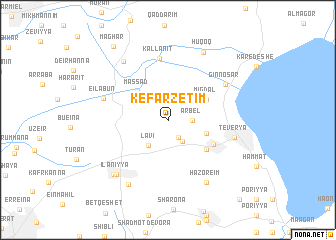
Kefar Zetim (HaẔafon, Israel)Kefar Zetim is a town in the HaẔafon region of Israel. An overview map of the region around Kefar Zetim is displayed below.
regional and 3d topo map of Kefar Zetim, Israel ::
Kefar Zetim airports ::
The nearest airport is RPN - Rosh Pina Mahanaim I Ben Yaakov, located 21.3 km north east of Kefar Zetim.
Other airports nearby include HFA - Haifa (39.2 km west), OMF - Mafraq King Hussein (90.4 km south east), SDV - Tel-aviv Sde Dov (100.4 km south west), TLV - Tel-aviv Ben Gurion (104.0 km south west), Nearby towns ::
Aẖuzzat Naftali (2.2km south east) //
Arbel (2.3km east) //
H̱ela (2.8km south east) //
Lavi (3.4km south west) //
Kefar H̱ittim (3.9km east) //
Massad (4.3km north west) //
Migdal (4.3km north east) //
Bet Ma‘on (4.9km south east) //
Miẕpa (5.0km south east) //
Kallanit (6.9km north) //
Ginnosar (6.7km north east) //
‘Eilabūn (6.5km west) //
Teverya (6.6km east) //
HaZore‘im (7.9km south east) //
Tefahot (7.8km north west) //
Ilaniyya (7.8km south west) //
Sede Ilan (8.0km south west) //
H̱uqoq (8.2km north east) //
H̱awwat HaShomer (7.9km south west) //
Maghār (9.7km north west) //
Poriyya (11.1km south east) //
[all distances 'as the bird flies' and approximate]  Places with similar names to Kefar Zetim, Israel :: Disclaimer :: Information on this page comes without warranty of any kind |
||
|
Where is Kefar Zetim? Elevation and coordinates ::
Latitude (lat): 32°48'47"N Longitude (lon): 35°27'41"E
Elevation (approx.): 46m (map arrows pan, magnifying glasses zoom) |
||
|
Visiting Kefar Zetim? Hotel/Accommodation ::
Book a hotel in Kefar Zetim Travel Guide ::
Buy a travel guide for Israel rental cars ::
car rental offers GPS waypoint ::
download a GPX waypoint (PoI) of Kefar Zetim for your GPS receiver
|
||