|
search place name
|
||
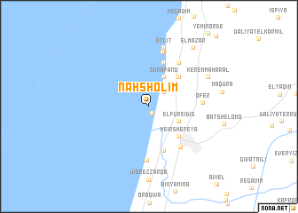
Naẖsholim (Israel)Naẖsholim is a town in Israel. An overview map of the region around Naẖsholim is displayed below.
regional and 3d topo map of Naẖsholim, Israel ::
Naẖsholim airports ::
The nearest airport is HFA - Haifa, located 24.4 km north east of Naẖsholim.
Other airports nearby include SDV - Tel-aviv Sde Dov (57.1 km south), TLV - Tel-aviv Ben Gurion (67.2 km south), RPN - Rosh Pina Mahanaim I Ben Yaakov (73.5 km north east), ADJ - Amman Marka Intl (123.9 km south east), Nearby towns ::
Dor (0.9km south east) //
‘En Ayyala (2.4km north east) //
Kafr Lām (2.4km north east) //
HaBonim (2.4km north east) //
Ẕerufa (3.5km north east) //
Sarafand (4.0km north east) //
El Fureidīs (3.6km south east) //
Geva‘ Karmel (4.8km north east) //
Meʼir Shefeya (4.8km south east) //
Esh Sheikh Bureik (5.8km north) //
Ma‘yan Ẕevi (5.8km south) //
Zikhron Ya‘aqov (6.1km south east) //
‘En Karmel (6.4km north east) //
Ma‘agan Mikhaʼel (6.8km south) //
‘Ofer (5.7km east) //
Newe Yam (7.0km north) //
‘Atlit (7.6km north) //
Kerem Maharal (7.3km north east) //
El Mazār (8.8km north east) //
[all distances 'as the bird flies' and approximate]  Places with similar names to Naẖsholim, Israel ::
Disclaimer :: Information on this page comes without warranty of any kind |
||
|
Where is Naẖsholim? Elevation and coordinates ::
Latitude (lat): 32°37'0"N Longitude (lon): 34°55'0"E
Elevation (approx.): 9m (map arrows pan, magnifying glasses zoom) |
||
|
Visiting Naẖsholim? Hotel/Accommodation ::
Book a hotel in Naẖsholim Travel Guide ::
Buy a travel guide for Israel rental cars ::
car rental offers GPS waypoint ::
download a GPX waypoint (PoI) of Naẖsholim for your GPS receiver
|
||