|
search place name
|
||
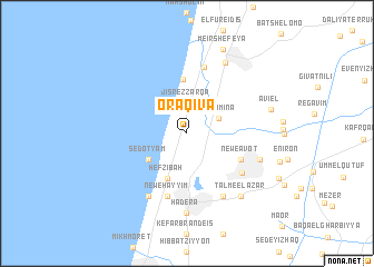
Or ‘Aqiva (Israel)Or ‘Aqiva is a town in Israel. An overview map of the region around Or ‘Aqiva is displayed below.
regional and 3d topo map of Or ‘Aqiva, Israel ::
Or ‘Aqiva airports ::
The nearest airport is HFA - Haifa, located 35.5 km north of Or ‘Aqiva.
Other airports nearby include SDV - Tel-aviv Sde Dov (45.4 km south), TLV - Tel-aviv Ben Gurion (55.1 km south), RPN - Rosh Pina Mahanaim I Ben Yaakov (80.8 km north east), ADJ - Amman Marka Intl (117.3 km south east), Nearby towns ::
Jisr ez Zarqā (2.9km north) //
Bet H̱ananya (2.9km north) //
Binyamina (3.1km north east) //
Sedot Yam (4.2km south west) //
H̱efẕi Bah (4.8km south) //
Ma‘agan Mikhaʼel (5.4km north) //
Newe Avot (5.3km south east) //
Newe H̱ayyim (6.6km south) //
Ma‘yan Ẕevi (6.8km north) //
Pardes H̱anna (6.2km south east) //
Gan Shemuʼel (7.1km south east) //
Giv‘at Olga (7.1km south west) //
Mishmarot (6.7km south east) //
H̱adera (8.0km south) //
Zikhron Ya‘aqov (7.7km north east) //
Talme El‘azar (7.9km south east) //
Aviʼel (7.5km east) //
Meʼir Shefeya (9.0km north) //
[all distances 'as the bird flies' and approximate]  Places with similar names to Or ‘Aqiva, Israel ::
Disclaimer :: Information on this page comes without warranty of any kind |
||
|
Where is Or ‘Aqiva? Elevation and coordinates ::
Latitude (lat): 32°30'26"N Longitude (lon): 34°55'3"E
Elevation (approx.): 18m (map arrows pan, magnifying glasses zoom) |
||
|
Visiting Or ‘Aqiva? Hotel/Accommodation ::
Book a hotel in Or ‘Aqiva Travel Guide ::
Buy a travel guide for Israel rental cars ::
car rental offers GPS waypoint ::
download a GPX waypoint (PoI) of Or ‘Aqiva for your GPS receiver
|
||