|
search place name
|
||
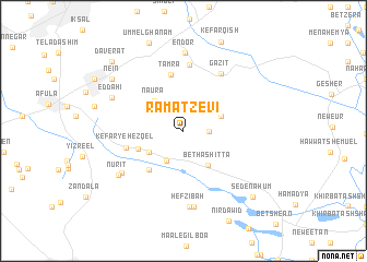
Ramat Ẕevi (HaẔafon, Israel)Ramat Ẕevi is a town in the HaẔafon region of Israel. An overview map of the region around Ramat Ẕevi is displayed below.
regional and 3d topo map of Ramat Ẕevi, Israel ::
Ramat Ẕevi airports ::
The nearest airport is HFA - Haifa, located 42.8 km north west of Ramat Ẕevi.
Other airports nearby include RPN - Rosh Pina Mahanaim I Ben Yaakov (46.2 km north), SDV - Tel-aviv Sde Dov (79.3 km south west), TLV - Tel-aviv Ben Gurion (80.9 km south west), OMF - Mafraq King Hussein (83.3 km east), Nearby towns ::
Moledet (2.2km east) //
Tel Yosef (3.4km south west) //
Eṭ Ṭaiyiba (3.6km north east) //
‘En H̱arod Iẖud (3.7km south west) //
Nā‘ūra (3.9km north west) //
Bet HaShitta (4.1km south east) //
Geva‘ (4.3km south west) //
‘En H̱arod (5.0km south west) //
‘En H̱arod Meʼuẖad (5.0km south west) //
Tamra (5.8km north) //
Kefar Yeẖezqel (5.2km west) //
Kafr Miṣr (6.8km north) //
Gazit (6.7km north east) //
Gid‘ona (6.9km south west) //
H̱efẕi Bah (7.7km south) //
Bet Alfa (7.8km south) //
Nurit (7.2km south west) //
Ed Daḥī (7.0km north west) //
‘En Dor (8.0km north) //
Nein (8.1km north west) //
Sede Naẖum (9.1km south east) //
Daverat (9.4km north west) //
[all distances 'as the bird flies' and approximate]  Places with similar names to Ramat Ẕevi, Israel :: Disclaimer :: Information on this page comes without warranty of any kind |
||
|
Where is Ramat Ẕevi? Elevation and coordinates ::
Latitude (lat): 32°35'10"N Longitude (lon): 35°24'55"E
Elevation (approx.): 58m (map arrows pan, magnifying glasses zoom) |
||
|
Visiting Ramat Ẕevi? Hotel/Accommodation ::
Book a hotel in Ramat Ẕevi Travel Guide ::
Buy a travel guide for Israel rental cars ::
car rental offers GPS waypoint ::
download a GPX waypoint (PoI) of Ramat Ẕevi for your GPS receiver
|
||