|
search place name
|
||
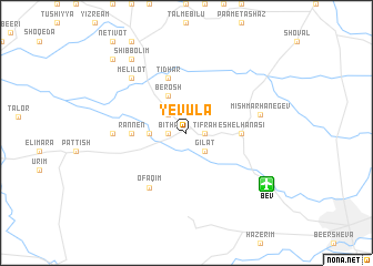
Yevula (HaDarom, Israel)Yevula is a town in the HaDarom region of Israel. An overview map of the region around Yevula is displayed below.
regional and 3d topo map of Yevula, Israel ::
Yevula airports ::
The nearest airport is BEV - Beer-sheba Teyman, located 8.6 km south east of Yevula.
Other airports nearby include TLV - Tel-aviv Ben Gurion (78.5 km north), SDV - Tel-aviv Sde Dov (87.5 km north), AMM - Amman Queen Alia Intl (134.7 km east), ADJ - Amman Marka Intl (145.7 km north east), Nearby towns ::
Tifraẖ (1.6km east) //
Bitẖa (1.6km west) //
Gilat (2.4km south east) //
Migda (2.4km north west) //
Peduyim (3.2km west) //
Teʼashur (4.0km north west) //
Berosh (4.0km north west) //
Rannen (4.7km west) //
Eshel HaNasi (4.7km east) //
Tidhar (5.8km north) //
Ofaqim (6.4km south west) //
Maslul (6.3km west) //
Mishmar HaNegev (6.6km east) //
Melilot (7.3km north west) //
Sharsheret (8.8km north west) //
Shibbolim (8.8km north west) //
Ma‘galim (8.8km north west) //
Giv‘olim (9.7km north west) //
[all distances 'as the bird flies' and approximate] 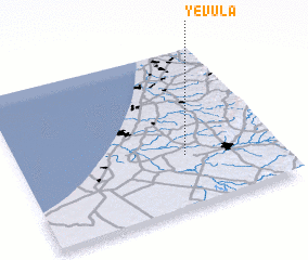 Places with similar names to Yevula, Israel ::
Disclaimer :: Information on this page comes without warranty of any kind |
||
|
Where is Yevula? Elevation and coordinates ::
Latitude (lat): 31°20'0"N Longitude (lon): 34°39'0"E
Elevation (approx.): 131m (map arrows pan, magnifying glasses zoom) |
||
|
Visiting Yevula? Hotel/Accommodation ::
Book a hotel in Yevula Travel Guide ::
Buy a travel guide for Israel rental cars ::
car rental offers GPS waypoint ::
download a GPX waypoint (PoI) of Yevula for your GPS receiver
|
||